
Bagn topographic map
Interactive map
Click on the map to display elevation.
About this map
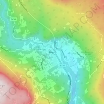
Name: Bagn topographic map, elevation, terrain.
Location: Bagn, Sør-Aurdal, Innlandet, Noorwegen (60.80260 9.53231 60.84260 9.57231)
Average elevation: 462 m
Minimum elevation: 222 m
Maximum elevation: 900 m
Other topographic maps
Click on a map to view its topography, its elevation and its terrain.
Feforvatnet
Feforvatnet, Nord-Fron, Innlandet, Noorwegen
Average elevation: 890 m
Balbergkampen
Balbergkampen, Lillehammer, Innlandet, 2624, Noorwegen
Average elevation: 447 m
Skeikampen
Skeikampen, Gausdal, Innlandet, 2652, Noorwegen
Average elevation: 918 m