
Hamar topographic map
Interactive map
Click on the map to display elevation.
About this map
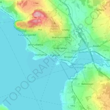
Name: Hamar topographic map, elevation, terrain.
Location: Hamar, Innlandet, 2317, Noorwegen (60.63472 10.90806 60.95472 11.22806)
Average elevation: 267 m
Minimum elevation: 117 m
Maximum elevation: 757 m
Other topographic maps
Click on a map to view its topography, its elevation and its terrain.
Feforvatnet
Feforvatnet, Nord-Fron, Innlandet, Noorwegen
Average elevation: 890 m
Balbergkampen
Balbergkampen, Lillehammer, Innlandet, 2624, Noorwegen
Average elevation: 447 m
Skeikampen
Skeikampen, Gausdal, Innlandet, 2652, Noorwegen
Average elevation: 918 m