
Gålå topographic map
Interactive map
Click on the map to display elevation.
About this map
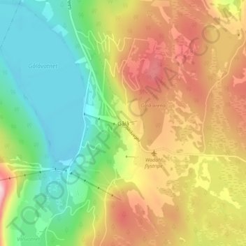
Name: Gålå topographic map, elevation, terrain.
Location: Gålå, Sør-Fron, Innlandet, 2646, Noorwegen (61.48581 9.76471 61.52581 9.80471)
Average elevation: 903 m
Minimum elevation: 779 m
Maximum elevation: 1,067 m
Other topographic maps
Click on a map to view its topography, its elevation and its terrain.
Feforvatnet
Feforvatnet, Nord-Fron, Innlandet, Noorwegen
Average elevation: 890 m
Balbergkampen
Balbergkampen, Lillehammer, Innlandet, 2624, Noorwegen
Average elevation: 447 m
Skeikampen
Skeikampen, Gausdal, Innlandet, 2652, Noorwegen
Average elevation: 918 m