Geolocate
👉 Easily get elevation data in JSON, GeoTIFF and KML formats using Elevation API
Thank you for supporting this site ❤️
Make a donation

Natunuan topographic map

Click on the map to display elevation.

👉 Easily get elevation data in JSON, GeoTIFF and KML formats using Elevation API
Thank you for supporting this site ❤️
Make a donation

About this map

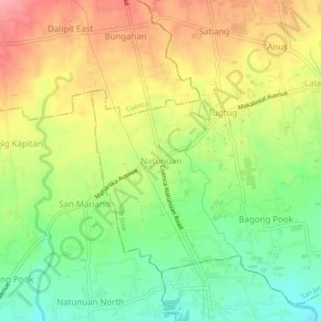
Name: Natunuan topographic map, elevation, terrain.

Location: Natunuan, San Jose, Batangas, Calabarzon, 4227, Philippines (13.83427 121.03807 13.87427 121.07807)

Average elevation: 191 m

Minimum elevation: 141 m

Maximum elevation: 245 m

Other topographic maps

Click on a map to view its topography, its elevation and its terrain.

Aya

Philippines > Batangas > San Jose

Average elevation: 271 m

Calansayan

Philippines > Batangas > San Jose > Dagatan

Average elevation: 188 m

Santo Cristo

Philippines > Batangas > San Jose

Average elevation: 221 m

Aguila

Philippines > Batangas > San Jose

Average elevation: 168 m