Geolocate
👉 Easily get elevation data in JSON, GeoTIFF and KML formats using Elevation API
Thank you for supporting this site ❤️
Make a donation

Balaytigue topographic map

Click on the map to display elevation.

👉 Easily get elevation data in JSON, GeoTIFF and KML formats using Elevation API
Thank you for supporting this site ❤️
Make a donation

About this map

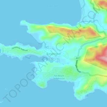
Name: Balaytigue topographic map, elevation, terrain.

Location: Balaytigue, Nasugbu, Batangas, Calabarzon, 4231, Philippines (14.11170 120.57810 14.15170 120.61810)

Average elevation: 23 m

Minimum elevation: -1 m

Maximum elevation: 188 m

Other topographic maps

Click on a map to view its topography, its elevation and its terrain.

Palico River

Philippines > Batangas > Nasugbu > Reparo

Average elevation: 44 m

Batulao

Philippines > Batangas > Nasugbu

Average elevation: 531 m

Pico de Loro Beach

Philippines > Batangas > Nasugbu

Average elevation: 43 m

Fortune Island

Philippines > Batangas > Nasugbu

Average elevation: 1 m

Talamitam

Philippines > Batangas > Nasugbu > Kayrilaw

Average elevation: 328 m

Fortune Island

Philippines > Batangas > Nasugbu

Average elevation: 1 m