
Thank you for supporting this site ❤️
Make a donation
Make a donation
San Pedro topographic map
Click on the map to display elevation.
Thank you for supporting this site ❤️
Make a donation
Make a donation
About this map
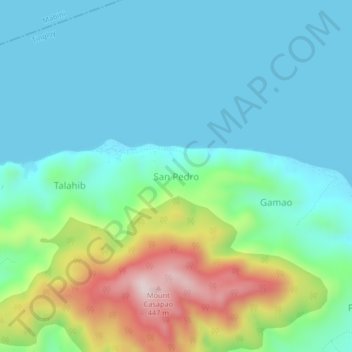
Name: San Pedro topographic map, elevation, terrain.
Location: San Pedro, Tingloy, Batangas, Calabarzon, Philippines (13.63479 120.89538 13.67479 120.93538)
Average elevation: 109 m
Minimum elevation: 0 m
Maximum elevation: 447 m
Thank you for supporting this site ❤️
Make a donation
Make a donation
Other topographic maps
Click on a map to view its topography, its elevation and its terrain.