Geolocate
👉 Easily get elevation data in JSON, GeoTIFF and KML formats using Elevation API
Thank you for supporting this site ❤️
Make a donation

Balibago topographic map

Click on the map to display elevation.

👉 Easily get elevation data in JSON, GeoTIFF and KML formats using Elevation API
Thank you for supporting this site ❤️
Make a donation

About this map

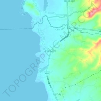
Name: Balibago topographic map, elevation, terrain.

Location: Balibago, Calatagan, Batangas, Calabarzon, 4215, Philippines (13.90449 120.60486 13.94449 120.64486)

Average elevation: 17 m

Minimum elevation: -4 m

Maximum elevation: 113 m

Other topographic maps

Click on a map to view its topography, its elevation and its terrain.

Burot Beach

Philippines > Batangas > Calatagan

Average elevation: 3 m

Pagapas Bay

Philippines > Batangas > Calatagan

Average elevation: 15 m