
Gansu topographic map
Interactive map
Click on the map to display elevation.
About this map
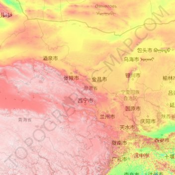
Name: Gansu topographic map, elevation, terrain.
Location: Gansu, China (32.59871 92.33865 42.79457 108.71053)
Average elevation: 2,260 m
Minimum elevation: 288 m
Maximum elevation: 6,009 m
Gansu generally has a semi-arid to arid continental climate (Köppen BSk or BWk) with warm to hot summers and cold to very cold winters, although diurnal temperature ranges are often so large that maxima remain above 0 °C (32 °F) even in winter. However, due to extreme altitude, some areas of Gansu exhibit a subarctic climate (Dwc) – with winter temperatures sometimes dropping to −40 °C (−40 °F). Most of the limited precipitation is delivered in the summer months: winters are so dry that snow cover is confined to very high altitudes and the snow line can be as high as 5,500 metres (18,040 ft) in the southwest.
Other topographic maps
Click on a map to view its topography, its elevation and its terrain.
Double Island
China > Hong Kong > North District > Tung Wan
Double Island, Tung Wan, North District, New Territories, Hong Kong, China
Average elevation: 12 m
Lanting
China > Jiangxi > Hukou County > Junqiao
Lanting, Junqiao, Hukou County, Jiangxi, China
Average elevation: 23 m
Labo River
China > Sichuan > Litang County > Nabo > Zhazha
Labo River, Zhazha, Nabo, Litang County, Kardze, Sichuan, China
Average elevation: 3,708 m
Fenghuang Mountain
China > Zhejiang > Hangzhou City
Fenghuang Mountain, Hangzhou City, Zhejiang, 310002, China
Average elevation: 44 m
Fenghuang County
Fenghuang County, Xiangxi, Hunan, 416200, China
Average elevation: 497 m
Bao'an District
Bao'an District, Shenzhen, Guangdong Province, 518100, China
Average elevation: 36 m
Kashgar Prefecture
China > Xinjiang > Kashgar City
Kashgar Prefecture, Kashgar City, Kachgar, Xinjiang, 844000, China
Average elevation: 2,275 m
Lian River
China > Jiangxi > Yudu County
Lian River, Yudu County, Ganzhou, Jiangxi, China
Average elevation: 243 m
Golog Tibetan Autonomous Prefecture
China > Qinghai > Gadê County
Golog Tibetan Autonomous Prefecture, Gadê County, Golog, Qinghai, China
Average elevation: 4,340 m
Heihe
China > Heilongjiang > 幸福乡
Heihe, 幸福乡, Aihui District, Heihe City, Heilongjiang, 164300, China
Average elevation: 174 m
Mudanjiang
Mudanjiang, Revitalize the streets, Dong'an District, Mudanjiang City, Heilongjiang, 157000, China
Average elevation: 361 m
Shui Choi Tin Village
China > Hong Kong > Hong Kong Island
Shui Choi Tin Village, Southern District, Hong Kong Island, Hong Kong, China
Average elevation: 94 m
Baotou City
Baotou City, Inner Mongolia, 014000, China
Average elevation: 1,318 m
Chengguan District
Chengguan District, Lhasa, Tibet, 850000, China
Average elevation: 4,325 m