
Make a donation
Idaho topographic map
Click on the map to display elevation.
Make a donation
Idaho
Idaho's climate varies widely. Although the state's western border is about 330 miles (530 km) from the Pacific Ocean, the maritime influence is still felt in Idaho; especially, in the winter when cloud cover, humidity, and precipitation are at their maximum extent. This influence has a moderating effect in the winter where temperatures are not as low as would otherwise be expected for a northern state with predominantly high elevations. In the panhandle, moist air masses from the coast are released as precipitation over the North Central Rockies forests, creating the North American inland temperate rainforest. The maritime influence is least prominent in the state's eastern part where the precipitation patterns are often reversed, with wetter summers and drier winters, and seasonal temperature differences are more extreme, showing a more semi-arid continental climate.
Make a donation
About this map
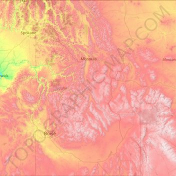
Name: Idaho topographic map, elevation, terrain.
Location: Idaho, United States (41.98883 -117.24303 49.00084 -111.04356)
Average elevation: 1,533 m
Minimum elevation: 102 m
Maximum elevation: 4,034 m
Make a donation
Other topographic maps
Click on a map to view its topography, its elevation and its terrain.
Mississippi River
United States > Illinois > Hancock County > Pontoosuc
The uppermost lock and dam on the Upper Mississippi River is the Upper St. Anthony Falls Lock and Dam in Minneapolis. Above the dam, the river's elevation is 799 feet (244 m). Below the dam, the river's elevation is 750 feet (230 m). This 49-foot (15 m) drop is the largest of all the Mississippi River locks…
Average elevation: 161 m
New York
United States > New York > New York County
The city's land has been altered substantially by human intervention, with considerable land reclamation along the waterfronts since Dutch colonial times; reclamation is most prominent in Lower Manhattan, with developments such as Battery Park City in the 1970s and 1980s. Some of the natural relief in…
Average elevation: 15 m
Make a donation
Mohawk River
United States > New York > Schenectady County > City of Schenectady > East Glenville
Average elevation: 74 m
Make a donation
Make a donation
Buford Horizons Mobile Home Park
United States > Georgia > Gwinnett County > Buford
Average elevation: 328 m
Mauna Loa
United States > Hawaii > Hawaiʻi County
Mauna Loa is the largest subaerial and second largest overall volcano in the world (behind Tamu Massif), covering a land area of 5,271 km2 (2,035 sq mi) and spans a maximum width of 120 km (75 mi). Consisting of approximately 65,000 to 80,000 km3 (15,600 to 19,200 cu mi) of solid rock, it makes up more than…
Average elevation: 4,037 m
East Summit
United States > Connecticut > Northwest Hills Planning Region > Norfolk
Average elevation: 431 m
Make a donation
Make a donation
Cornwells Heights
United States > Pennsylvania > Bucks County > Bensalem Township
Average elevation: 16 m
Make a donation
Make a donation
Hancock
United States > Connecticut > Naugatuck Valley Planning Region > Plymouth
Average elevation: 217 m
Make a donation
Tiana
United States > New York > Suffolk County > Hampton Bays > Town of Southampton
Average elevation: 12 m
Frazer
United States > Pennsylvania > Chester County > East Whiteland Township
Average elevation: 142 m
Make a donation
Make a donation
Make a donation
Make a donation
Wood
United States > Pennsylvania > Bucks County > Bristol Township > Levittown
Average elevation: 15 m
Make a donation
Sunny Rest Lodge
United States > Pennsylvania > Carbon County > Franklin Township
Average elevation: 237 m
Make a donation
Make a donation
Make a donation
North Stelton
United States > New Jersey > Middlesex County > Piscataway Township
Average elevation: 29 m
Make a donation
Great Plains
United States > Kansas > Thomas County
The North American Environmental Atlas, produced by the Commission for Environmental Cooperation, a North American Free Trade Agreement (NAFTA) agency composed of the geographical agencies of the Mexican, American, and Canadian governments, uses the "Great Plains" as an ecoregion synonymous with predominant…
Average elevation: 1,023 m
Make a donation
Make a donation
Make a donation
Make a donation
Sassafrass Natural Resource Management Area
United States > Maryland > Kent County > Knocks Folly
Average elevation: 14 m
Make a donation
Make a donation
Crescent Heights
United States > New Jersey > Burlington County > Southampton Township
Average elevation: 17 m
Glenrose
United States > Pennsylvania > Chester County > East Fallowfield Township
Average elevation: 154 m
Terryville
United States > Connecticut > Naugatuck Valley Planning Region > Plymouth
Average elevation: 216 m
Make a donation
Lake Chaffee
United States > Connecticut > Northeastern Connecticut Planning Region
Average elevation: 269 m
Make a donation