
New York topographic map
Click on the map to display elevation.
New York
The city's land has been altered substantially by human intervention, with considerable land reclamation along the waterfronts since Dutch colonial times; reclamation is most prominent in Lower Manhattan, with developments such as Battery Park City in the 1970s and 1980s. Some of the natural relief in topography has been evened out, especially in Manhattan.
About this map
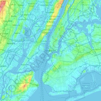
Name: New York topographic map, elevation, terrain.
Location: New York, New York County, New York, 10000, United States (40.55273 -74.16602 40.87273 -73.84602)
Average elevation: 15 m
Minimum elevation: -10 m
Maximum elevation: 186 m
Other topographic maps
Click on a map to view its topography, its elevation and its terrain.
Central Park
United States > New York > New York County > New York
In June 1856, Fernando Wood appointed a "consulting board" of seven people, headed by author Washington Irving, to inspire public confidence in the proposed development. Wood hired military engineer Egbert Ludovicus Viele as the park's chief engineer, tasking him with a topographical survey of the site. The…
Average elevation: 26 m