Geolocate

Philippines topographic map

Interactive map

Click on the map to display elevation.

Philippines

The Philippines is an archipelago of approximately 7,641 islands, with a total land area of about 300,000 square kilometers. The terrain is predominantly mountainous, with narrow coastal plains and valleys. The highest peak is Mount Apo on Mindanao, reaching 2,954 meters (9,692 feet) above sea level. Other notable mountains include Mount Pulag in Luzon and Mount Dulang-Dulang in Mindanao. The Sierra Madre mountain range, the longest in the Philippines, stretches along the eastern side of Luzon. The country is also home to several active volcanoes, such as Mayon, Taal, and Canlaon, contributing to its varied topography. The extensive coastline, measuring 36,289 kilometers (22,549 miles), features numerous bays, coves, and inlets, with Manila Bay being one of the finest harbors in East Asia. The Philippines' diverse landscape includes fertile plains like the Central Luzon plains, known as the "Rice Bowl of the Philippines," and the Cagayan Valley, which is the country's longest river system. The varied terrain has led to a rich biodiversity, with tropical rainforests providing habitats for numerous species. The country's location along the Pacific Ring of Fire makes it prone to earthquakes and volcanic activity, further shaping its dynamic landscape.

About this map

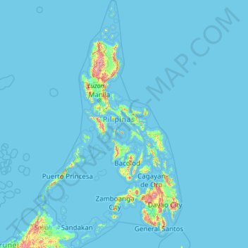
Name: Philippines topographic map, elevation, terrain.

Location: Philippines (4.38333 114.10369 21.32193 126.80308)

Average elevation: 33 m

Minimum elevation: -1 m

Maximum elevation: 2,639 m

Other topographic maps

Click on a map to view its topography, its elevation and its terrain.

Boise

United States of America > Idaho > Boise

Boise (/ˈbɔɪsi/ (listen)) is the capital and most populous city of the U.S. state of Idaho, and is the county seat of Ada County. Located on the Boise River in southwestern Idaho, it is 41 miles (66 km) east of the Oregon border, and 110 miles (177 km) north of the Nevada border. The downtown area's…

Average elevation: 1,040 m

Cebu City

Philippines > Cebu > Cebu City

Average elevation: 140 m

Quezon City

Philippines

Founded as a pueblo by Saint Pedro Bautista in 1590, San Francisco del Monte may be considered Quezon City's oldest district. The original land area of the old town of San Francisco del Monte was approximately2.5 square kilometres (1.0 sq mi) and covered parts of what is currently known as Project 7 and 8 and…

Average elevation: 57 m

Taliktik

Philippines > Isabela

Average elevation: 269 m

Malolos

Philippines > Bulacan

Malolos is relatively flat of about 0.81% to a gently sloping of 2.17%. The slope of the land descends towards west, southwest to southern direction. The highest land elevation is at about 6.0 meters above sea level while the lowest is only half a meter below sea level. A network of natural waterways and…

Average elevation: 6 m

Morogoro

Tanzania > Morogoro Region

Average elevation: 655 m

Cairns

Australia > Queensland

South of Smithfield and inland from the Northern Beaches along the edge of the Barron River flood plain are the suburbs of Caravonica, Kamerunga, Freshwater, and Stratford. This area is sometimes referred to as Freshwater Valley, though it is actually the lower part of Redlynch Valley; further up the valley…

Average elevation: 176 m

Santa Rosa

Philippines > Laguna > Santa Rosa

Average elevation: 65 m

Lapu-Lapu

Philippines

Average elevation: 93 m

Mandaluyong

Philippines

Another claims that the Spaniards named the place based on the report of a navigator named Acapulco, who saw the rolling hills frequently being lashed at by daluyong (“big waves from the sea”). This seems to confirm traditional pre-Hispanic stories that giant waves from the sea would meet the adjoining…

Average elevation: 33 m

Washington, D.C.

United States of America > Washington, D.C. > Washington, D.C.

The highest natural elevation in the District is 409 feet (125 m) above sea level at Fort Reno Park in upper northwest Washington. The lowest point is sea level at the Potomac River. The geographic center of Washington is near the intersection of 4th and L Streets NW.

Average elevation: 63 m

Bacoor

Philippines > Cavite

Average elevation: 18 m

Capalonga

Philippines > Camarines Norte

Average elevation: 13 m

Escaler

Philippines > Pampanga > Magalang

Average elevation: 16 m

Bagtong

Philippines > Eastern Samar > Salcedo

Average elevation: 16 m

East Dirita

Philippines > Zambales > San Antonio

Average elevation: 15 m

Sumilon

Philippines > Surigao Del Norte

Average elevation: 1 m

Cuaming

Philippines > Bohol > Inabanga

Average elevation: 0 m

Bacolod

Philippines

Bacólod (English: Bacolod), is derived from bakólod (Old Spelling: bacólod), the Old Hiligaynon (Old Ilonggo) (Old Spelling: Ylongo and Ilongo) word for a "hill, turtle, mound, rise, hillock, down, any small eminence or elevation", since the resettlement was founded on a stony, hilly area, now the barangay…

Average elevation: 49 m

Carmen

Philippines > Bohol

Average elevation: 258 m

Basin

Philippines > Bukidnon > Maramag > Magsaysay

Average elevation: 662 m

Pulong Saging

Philippines > Cavite > Silang

Average elevation: 385 m

San Isidro

Philippines > Isabela

Average elevation: 74 m

San Augustin

Philippines > Leyte > Babatngon

Average elevation: 10 m

Calibato Lake

Philippines > Laguna > San Pablo > Santo Angel

Average elevation: 232 m

Masinloc

Philippines > Zambales

Average elevation: 13 m

Ungale

Philippines > Biliran

Average elevation: 67 m

Tayud

Philippines > Cebu

Average elevation: 9 m

Alfonso

Philippines > Cavite > Alfonso

Average elevation: 413 m

Rizal

Philippines > Quirino > Rizal

Average elevation: 130 m

Cabanatuan

Philippines > Nueva Ecija

Average elevation: 47 m

San Juan

Philippines

"San Juan" is a contraction of the city's traditional name of "San Juan del Monte" (lit. 'Saint John of the Mountain'). As with numerous other places in the Philippines, the name combines a patron saint and a toponym; in this case Saint John the Baptist with the locale's hilly terrain and relatively higher…

Average elevation: 35 m

Zamboanga City

Philippines > Zamboanga Peninsula > Zamboanga City

The overall topography of the city could be described as rolling to very steep. There are some flat lands, mostly narrow strips along the east coast. The urban center is mostly flat with a gentle slope to the interior, ranging from 0 to 3%. The highest registered elevation is 1,200 metres. In terms of slope, a…

Average elevation: 83 m

San Fernando

Philippines > Pampanga

Average elevation: 24 m

Sinilian First

Philippines > Tarlac > Camiling

Average elevation: 23 m

Lampanusan

Philippines > Bukidnon > Kalilangan

Average elevation: 437 m

Bharatpur

Nepal > Bagamati Province > Chitwan

Average elevation: 363 m

Dinahican

Philippines > Quezon > Infanta

Average elevation: 1 m

Planza

Philippines > Camarines Sur

Average elevation: 20 m

O'Donnell

Philippines > Tarlac > Capas

Average elevation: 128 m

Bancalan Island

Philippines > Palawan > Balabac

Average elevation: 6 m

Summit

Philippines > Quezon > Atimonan > San Rafael

Average elevation: 51 m

Montalban

Philippines > Rizal > Rodriguez

Rodriguez is generally very rough in topography, with 83% of its total land area composed of upland areas, hills and mountain ranges. The remaining 17% low-lying terrain and rolling lands are found at the south-western portion of the municipality, along with the northern portions of the Municipality of San…

Average elevation: 99 m

Tagaytay

Philippines > Cavite

The southern and eastern portions of Tagaytay are covered by hills and mountains which is generally forests, pine trees and open grasslands. The city lies along Tagaytay Ridge, a ridge stretching about 32 kilometres (20 mi) from Mount Batulao in the west to Mount Sungay in the east with elevations averaging…

Average elevation: 229 m

Sambungan

Philippines > Batangas > Calatagan

Average elevation: 37 m

Baguilawa

Philippines > Batangas > Bauan

Average elevation: 131 m

Sacsac

Philippines > Cebu > Consolacion

Average elevation: 82 m

Guinsang-an

Philippines > South Cotabato > Santo Niño

Average elevation: 118 m

Dugmanon

Philippines > Davao Oriental > San Isidro

Average elevation: 127 m

Buenavista

Philippines > Quezon

Average elevation: 66 m

Caloocan

Philippines > Caloocan > Caloocan

Average elevation: 19 m

Tanay

Philippines > Rizal

Average elevation: 32 m

Tărtăria

Romania > Alba

Average elevation: 261 m

Tipo

Indonesia > Central Sulawesi

Average elevation: 86 m

Malainen Luma

Philippines > Cavite > Naic

Average elevation: 54 m

Energy Park

Philippines > Davao del Norte > Tagum

Average elevation: 18 m

Red Bull Ring

Austria > Styria > Spielberg

Average elevation: 755 m

Amadeo

Philippines > Cavite > Amadeo

Average elevation: 422 m

Antipolo

Philippines > Rizal

Its higher elevation than that of Metro Manila affords it a scenic view of the metropolis, especially at night. Its locally grown mangoes and cashews are popular among tourists, as well as suman – a local delicacy made out of glutinous rice. The Hinulugang Taktak National Park, which was once a popular…

Average elevation: 125 m

Upa

Philippines > Batangas > Mataasnakahoy

Average elevation: 310 m

Sugpon

Philippines > Ilocos Sur

Average elevation: 222 m

Ramirez

Philippines > Cavite > Magallanes

Average elevation: 190 m

Malumpati Cold Spring

Philippines > Antique > Pandan > Buang > Santa Cruz

Average elevation: 72 m

San Pablo

Philippines > Laguna > San Pablo

Average elevation: 220 m

Pasay

Philippines

Average elevation: 14 m

San Martin

Philippines > Bukidnon > Malaybalay

Average elevation: 386 m

Ramirez

United States > California > Yuba County

Average elevation: 28 m

Lumondao

Philippines > Davao City

Average elevation: 488 m

Morki

India > Rajasthan > Khetri Tehsil

Average elevation: 549 m

Luciano

Philippines > Cavite > Trece Martires

Average elevation: 126 m

Bagong Silang

Philippines > Isabela > Ilagan

Average elevation: 56 m

Māpua

New Zealand

Average elevation: 23 m

Tunasan River

Philippines > Muntinlupa

Average elevation: 47 m

Samal Island

Philippines > Davao del Norte > Samal

Average elevation: 117 m

Calumpit

Philippines > Bulacan > Calumpit

Average elevation: 4 m

Iligan

Philippines

Average elevation: 229 m

Tuburan

Philippines > Cebu

Average elevation: 48 m

Myinmū

Myanmar > Sagaing Region > Sagaing District

Average elevation: 69 m

Townsite

Philippines > Bataan > Limay

Average elevation: 20 m

San Jose de Buan

Philippines > Samar

Average elevation: 299 m

Tatawiran

Philippines > Quezon > General Nakar

Average elevation: 617 m

Naga

Philippines > Cebu

Average elevation: 102 m

Butuan

Philippines

Average elevation: 115 m

Photo

Liberia > Grand Bassa County > District 2

Average elevation: 155 m

Nauring

Philippines > Antique > Pandan

Average elevation: 12 m

Purok 3

Philippines > Samar > Santa Margarita > Burabod

Average elevation: 13 m

Butig

Philippines > Lanao del Sur

Average elevation: 806 m

San Narciso

Philippines > Zambales

San Narciso is located in a relatively flat plain. West of the town is the South China Sea and to the east is bordered by the Sto. Tomas river are the Zambales Mountain Ranges. Average elevation is 3.6 metres (12 ft) above sea level and the highest elevation is 800 metres (2,600 ft) above sea level.

Average elevation: 11 m

Dalicanan

Philippines > Iloilo

Average elevation: 131 m

Tapoje

Peru > Puno > Yunguyo

Average elevation: 3,838 m

Valencia

Philippines > Negros Oriental > Valencia

Valencia occupies an area of 14,749 hectares (36,450 acres), 35% of which are classified as plains. The town is 65% mountainous, with elevation averaging from 200 to 500 metres (660 to 1,640 ft) above sea level, with the top of Mount Talinis at an elevation of 1,903 metres (6,243 ft) along the municipal…

Average elevation: 250 m

Talim Island

Philippines > Rizal > Kinaboogan

Average elevation: 13 m

Bantay

Philippines > Ilocos Sur

It has an average elevation of 100 meters (328.08 feet), with a land area of 7,660 hectares (18,900 acres). It is an elevated and hilly municipality but some barangays, especially those near creeks, are prone to flooding during heavy typhoons.

Average elevation: 8 m

Maslog

Philippines > Eastern Samar

Average elevation: 57 m

San Roque

Philippines > Bulacan > Pandi

Average elevation: 26 m