
Nordland topographic map
Interactive map
Click on the map to display elevation.
About this map
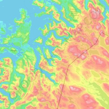
Name: Nordland topographic map, elevation, terrain.
Location: Tysfjord, Nordland, Noruega (67.64717 15.79457 68.31503 17.18050)
Average elevation: 488 m
Minimum elevation: -1 m
Maximum elevation: 1,719 m
Other topographic maps
Click on a map to view its topography, its elevation and its terrain.
Ellas have
Ellas have, Hestehaven, Nedre Vigeland, Vigeland, Lindesnes, Agder, Noruega
Average elevation: 79 m