
Ringvassøya topographic map
Interactive map
Click on the map to display elevation.
About this map
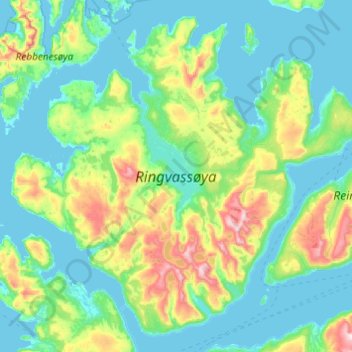
Name: Ringvassøya topographic map, elevation, terrain.
Location: Ringvassøya, Karlsøy, Troms, Noruega (69.78645 18.70281 70.09082 19.67607)
Average elevation: 171 m
Minimum elevation: -3 m
Maximum elevation: 1,039 m
Other topographic maps
Click on a map to view its topography, its elevation and its terrain.
Ellas have
Ellas have, Hestehaven, Nedre Vigeland, Vigeland, Lindesnes, Agder, Noruega
Average elevation: 79 m