
Seiland topographic map
Interactive map
Click on the map to display elevation.
About this map
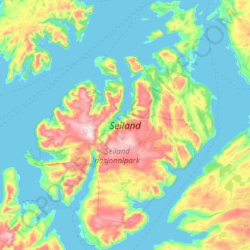
Name: Seiland topographic map, elevation, terrain.
Location: Seiland, Hammerfest, Finnmark, Noruega (70.27237 22.81540 70.62842 23.64312)
Average elevation: 216 m
Minimum elevation: -2 m
Maximum elevation: 1,066 m
Other topographic maps
Click on a map to view its topography, its elevation and its terrain.
Ellas have
Ellas have, Hestehaven, Nedre Vigeland, Vigeland, Lindesnes, Agder, Noruega
Average elevation: 79 m