
Tysnes topographic map
Interactive map
Click on the map to display elevation.
About this map
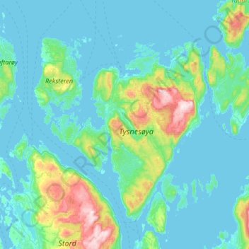
Name: Tysnes topographic map, elevation, terrain.
Location: Tysnes, Vestland, Noorwegen (59.85823 5.32212 60.12440 5.76973)
Average elevation: 97 m
Minimum elevation: -4 m
Maximum elevation: 737 m
Other topographic maps
Click on a map to view its topography, its elevation and its terrain.
Tunsbergdalsvatnet
Tunsbergdalsvatnet, Luster, Vestland, Noorwegen
Average elevation: 806 m
Vøringsfossen
Vøringsfossen, Eidfjord, Vestland, Noorwegen
Average elevation: 772 m
Norheimsund
Noorwegen > Vestland > Norheimsund
Norheimsund, Kvam herad, Vestland, Noorwegen
Average elevation: 199 m