
Kletten topographic map
Interactive map
Click on the map to display elevation.
About this map
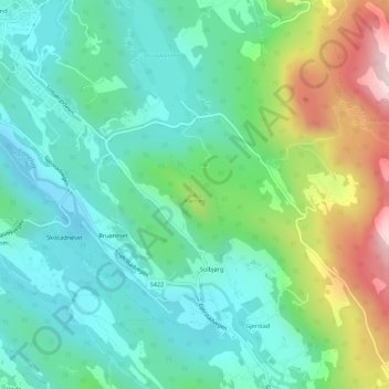
Name: Kletten topographic map, elevation, terrain.
Location: Kletten, Osterøy, Vestland, 5282, Noorwegen (60.51115 5.53748 60.51125 5.53758)
Average elevation: 128 m
Minimum elevation: 15 m
Maximum elevation: 414 m
Other topographic maps
Click on a map to view its topography, its elevation and its terrain.
Tunsbergdalsvatnet
Tunsbergdalsvatnet, Luster, Vestland, Noorwegen
Average elevation: 806 m
Vøringsfossen
Vøringsfossen, Eidfjord, Vestland, Noorwegen
Average elevation: 772 m
Norheimsund
Noorwegen > Vestland > Norheimsund
Norheimsund, Kvam herad, Vestland, Noorwegen
Average elevation: 199 m