
Voss topographic map
Interactive map
Click on the map to display elevation.
About this map
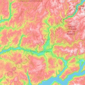
Name: Voss topographic map, elevation, terrain.
Location: Voss, Vestland, Noorwegen (60.41451 5.84275 60.95955 6.98587)
Average elevation: 765 m
Minimum elevation: 0 m
Maximum elevation: 1,652 m
Other topographic maps
Click on a map to view its topography, its elevation and its terrain.
Tunsbergdalsvatnet
Tunsbergdalsvatnet, Luster, Vestland, Noorwegen
Average elevation: 806 m
Vøringsfossen
Vøringsfossen, Eidfjord, Vestland, Noorwegen
Average elevation: 772 m
Norheimsund
Noorwegen > Vestland > Norheimsund
Norheimsund, Kvam herad, Vestland, Noorwegen
Average elevation: 199 m