
Turøyna topographic map
Interactive map
Click on the map to display elevation.
About this map
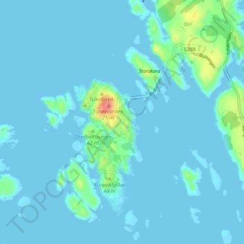
Name: Turøyna topographic map, elevation, terrain.
Location: Turøyna, Øygarden, Vestland, 5365, Noorwegen (60.42987 4.90035 60.46987 4.94035)
Average elevation: 7 m
Minimum elevation: -1 m
Maximum elevation: 74 m
Other topographic maps
Click on a map to view its topography, its elevation and its terrain.
Tunsbergdalsvatnet
Tunsbergdalsvatnet, Luster, Vestland, Noorwegen
Average elevation: 806 m
Vøringsfossen
Vøringsfossen, Eidfjord, Vestland, Noorwegen
Average elevation: 772 m
Norheimsund
Noorwegen > Vestland > Norheimsund
Norheimsund, Kvam herad, Vestland, Noorwegen
Average elevation: 199 m