
Tunsbergdalsvatnet topographic map
Interactive map
Click on the map to display elevation.
About this map
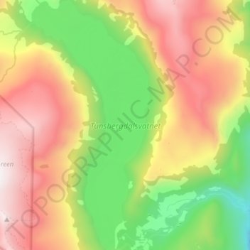
Name: Tunsbergdalsvatnet topographic map, elevation, terrain.
Location: Tunsbergdalsvatnet, Luster, Vestland, Noorwegen (61.46178 7.13795 61.52256 7.19800)
Average elevation: 806 m
Minimum elevation: 89 m
Maximum elevation: 1,650 m
Other topographic maps
Click on a map to view its topography, its elevation and its terrain.
Vøringsfossen
Vøringsfossen, Eidfjord, Vestland, Noorwegen
Average elevation: 772 m
Norheimsund
Noorwegen > Vestland > Norheimsund
Norheimsund, Kvam herad, Vestland, Noorwegen
Average elevation: 199 m