
Make a donation
Sichuan topographic map
Click on the map to display elevation.
Make a donation
Sichuan
Due to great differences in terrain, the climate of the province is highly variable. In general, it has strong monsoonal influences, with rainfall heavily concentrated in the summer. Under the Köppen climate classification, the Sichuan Basin (including Chengdu) in the eastern half of the province experiences a humid subtropical climate (Köppen Cwa or Cfa), with long, hot, wet summers and short, mild to cool, dry, and cloudy winters. Consequently, it has China's lowest sunshine totals. The western region has mountainous areas producing a cooler but sunnier climate. Having cool to very cold winters and mild summers, temperatures generally decrease with greater elevation. However, due to its high altitude and its inland location, many areas such as Garze County and Zoige County in Sichuan exhibit a subarctic climate (Köppen Dwc)- featuring extremely cold winters down to −30 °C and even cold summer nights. The region is geologically active with landslides and earthquakes. Average elevation ranges from 2,000 to 3,500 meters; average temperatures range from 0 to 15 °C. The southern part of the province, including Panzhihua and Xichang, has a sunny climate with short, very mild winters and very warm to hot summers.
Make a donation
About this map
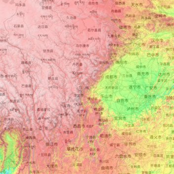
Name: Sichuan topographic map, elevation, terrain.
Location: Sichuan, China (26.04817 97.34738 34.31471 108.54267)
Average elevation: 2,522 m
Minimum elevation: 140 m
Maximum elevation: 6,536 m
Make a donation
Other topographic maps
Click on a map to view its topography, its elevation and its terrain.
Make a donation
Mudanjiang
It also borders Russia's Primorsky Krai to the east. The average elevation in the prefecture is 230 meters (755 ft), with the terrain primarily consisting of mountains and hills. The east of the prefecture begins to ascend to the Changbai Mountains, while the central parts belong to the Hegu Basin. The lowest…
Average elevation: 361 m
Make a donation
Golog Tibetan Autonomous Prefecture
China > Qinghai > Gadê County
The lay of the land of the prefecture is largely determined by the Amne Machin mountain range (max elevation 6,282 m), which runs in the general northwest- to-southeast direction across the entire prefecture, and beyond. The existence of the ridge results in one of the great bends of the Yellow River, which…
Average elevation: 4,340 m
Make a donation
Chongqing
The central urban area of Chongqing, or Chongqing proper, is a city of unique features. Built on mountains and partially surrounded by the Yangtze and Jialing rivers, it is known as a "mountain city" and a "city on rivers". The night scene of the city is very illuminated, with millions of lights and their…
Average elevation: 318 m
Make a donation
Make a donation
Victoria Peak
China > Hong Kong > Hong Kong Island
Victoria Peak is a hill on the western half of Hong Kong Island. It is also known as Mount Austin, and locally as The Peak. With an elevation of 552 metres (1,811 ft), it is the highest hill in Hong Kong island, ranked 29 in terms of elevation in Hong Kong (Tai Mo Shan is the highest point in Hong Kong with an…
Average elevation: 209 m
Make a donation
Beijing
Beijing is situated at the northern tip of the roughly triangular North China Plain, which opens to the south and east of the city. Mountains to the north, northwest and west shield the city and northern China's agricultural heartland from the encroaching desert steppes. The northwestern part of the…
Average elevation: 47 m
Make a donation
Make a donation
Make a donation
Shanghai
China > Huangpu District > Shanghai
The golden age of Shanghai began with its elevation to municipality after it was separated from Jiangsu on 7 July 1927. This new Chinese municipality covered an area of 494.69 km2 (191.0 sq mi), including the modern-day districts of Baoshan, Yangpu, Zhabei, Nanshi, and Pudong, but excluded the foreign…
Average elevation: 5 m