
Maine topographic map
Click on the map to display elevation.
Maine
Maine's topography is characterized by a diverse range of landscapes, from its rugged coastline to its mountainous interiors. The state is bordered by the Atlantic Ocean to the southeast, which features a mix of low-lying sandy beaches and rocky cliffs. Inland, the terrain transitions into rolling hills and flat plateaus, particularly prominent in the Aroostook County region known for its agricultural productivity. The western part of Maine is dominated by the Appalachian Mountains, including Mount Katahdin, the highest peak in the state at 5,267 feet (1,605 meters). This mountainous terrain is accompanied by a series of lakes, such as Moosehead and Sebago, and an extensive network of rivers and streams, adding to the intricate hydrology of the region. The average elevation of Maine is around 600 feet (183 meters), with significant variations throughout the state, showcasing a blend of coastal lowlands and elevated uplands that reflect the effects of glacial activity from the last ice age.
About this map
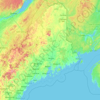
Name: Maine topographic map, elevation, terrain.
Location: Maine, United States (42.92222 -71.08417 47.45984 -66.88542)
Average elevation: 198 m
Minimum elevation: -3 m
Maximum elevation: 1,893 m
Other topographic maps
Click on a map to view its topography, its elevation and its terrain.
Mohawk River
United States > New York > Schenectady County > City of Schenectady > East Glenville
Average elevation: 74 m
New York
United States > New York > New York County
The city's land has been altered substantially by human intervention, with considerable land reclamation along the waterfronts since Dutch colonial times; reclamation is most prominent in Lower Manhattan, with developments such as Battery Park City in the 1970s and 1980s. Some of the natural relief in…
Average elevation: 15 m
Mississippi River
United States > Illinois > Hancock County > Pontoosuc
The uppermost lock and dam on the Upper Mississippi River is the Upper St. Anthony Falls Lock and Dam in Minneapolis. Above the dam, the river's elevation is 799 feet (244 m). Below the dam, the river's elevation is 750 feet (230 m). This 49-foot (15 m) drop is the largest of all the Mississippi River locks…
Average elevation: 161 m
Frazer
United States > Pennsylvania > Chester County > East Whiteland Township
Average elevation: 142 m
Mauna Loa
United States > Hawaii > Hawaiʻi County
Mauna Loa is the largest subaerial and second largest overall volcano in the world (behind Tamu Massif), covering a land area of 5,271 km2 (2,035 sq mi) and spans a maximum width of 120 km (75 mi). Consisting of approximately 65,000 to 80,000 km3 (15,600 to 19,200 cu mi) of solid rock, it makes up more than…
Average elevation: 4,037 m
Miami Canal
United States > Florida > Miami-Dade County > Miami > Fronton Trailer Park
Average elevation: 7 m
Buford Horizons Mobile Home Park
United States > Georgia > Gwinnett County > Buford
Average elevation: 328 m
Mount Shasta
United States > California > Siskiyou County
Mount Shasta (/ˈʃæstə/ SHASS-tə; Shasta: Waka-nunee-Tuki-wuki; Karuk: Úytaahkoo) is a potentially active volcano at the southern end of the Cascade Range in Siskiyou County, California. At an elevation of 14,179 ft (4,322 m), it is the second-highest peak in the Cascades and the fifth-highest in the…
Average elevation: 3,717 m
East Summit
United States > Connecticut > Northwest Hills Planning Region > Norfolk
Average elevation: 431 m
Cornwells Heights
United States > Pennsylvania > Bucks County > Bensalem Township
Average elevation: 16 m
Hancock
United States > Connecticut > Naugatuck Valley Planning Region > Plymouth
Average elevation: 217 m
Tiana
United States > New York > Suffolk County > Hampton Bays > Town of Southampton
Average elevation: 12 m
Central Park
United States > New York > New York County > New York
In June 1856, Fernando Wood appointed a "consulting board" of seven people, headed by author Washington Irving, to inspire public confidence in the proposed development. Wood hired military engineer Egbert Ludovicus Viele as the park's chief engineer, tasking him with a topographical survey of the site. The…
Average elevation: 26 m
Sunny Rest Lodge
United States > Pennsylvania > Carbon County > Franklin Township
Average elevation: 237 m
North Stelton
United States > New Jersey > Middlesex County > Piscataway Township
Average elevation: 29 m
Wood
United States > Pennsylvania > Bucks County > Bristol Township > Levittown
Average elevation: 15 m
Crescent Heights
United States > New Jersey > Burlington County > Southampton Township
Average elevation: 17 m
Glenrose
United States > Pennsylvania > Chester County > East Fallowfield Township
Average elevation: 154 m
Lake Chaffee
United States > Connecticut > Northeastern Connecticut Planning Region
Average elevation: 269 m