
Padre Burgos topographic map
Interactive map
Click on the map to display elevation.
About this map
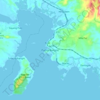
Name: Padre Burgos topographic map, elevation, terrain.
Location: Padre Burgos, Calabarzon, 4303, Philippines (13.87594 121.77495 13.95594 121.85495)
Average elevation: 19 m
Minimum elevation: -1 m
Maximum elevation: 236 m
On January 1, 1917, the village of Laguimanoc, which was formerly a barrio of Atimonan, became a municipality. On December 3, 1927, the town's name was changed to Padre Burgos by virtue of Act No. 3389, in honor of one of the country's martyrs, Fr. Jose Burgos. The streets were named after local leaders who rendered valuable services to the community. Because of the physical and topographic conditions of the town, four sitios where clusters of houses were became the main district of the town, namely: Campo, Burgos, Basiao and Bundok-Punta. The community converged to be in this particular spot because of its sea which made this town as port of Laguimanoc. In the early days this port offered a good wharf for vessels plying between Manila and southern Luzon. This was also a port of call for ships exporting lumber to Europe during the Spanish regime. In this town was the residence of the “Alcalde Mar” or Port Officer.
Other topographic maps
Click on a map to view its topography, its elevation and its terrain.
Mandaluyong
Mandaluyong, Eastern Manila District, Metro Manila, 1551, Philippines
Average elevation: 33 m
Cebu City
Philippines > Cebu > Cebu City
Cebu City, Cebu, Central Visayas, 6000, Philippines
Average elevation: 140 m
Baguio
Baguio, Cordillera Administrative Region, 2600, Philippines
Average elevation: 1,371 m
San Pablo
Philippines > Laguna > San Pablo
San Pablo, Laguna, Calabarzon, 4000, Philippines
Average elevation: 220 m
Mayapay
Philippines > Aklan > Buruanga
Mayapay, Buruanga, Aklan, Western Visayas, 5613, Philippines
Average elevation: 96 m
Datal Bila
Philippines > Sarangani > Malungon
Datal Bila, Malungon, Sarangani, Philippines
Average elevation: 790 m
Sindangan
Philippines > Zamboanga del Norte
Sindangan, Zamboanga del Norte, Zamboanga Peninsula, 7112, Philippines
Average elevation: 29 m
Zamboanga City
Philippines > Zamboanga Peninsula > Zamboanga City
Zamboanga City, Zamboanga Peninsula, 7000, Philippines
Average elevation: 83 m
Tuguegarao
Tuguegarao, Cagayan, Cagayan Valley, 3500, Philippines
Average elevation: 49 m
Masara
Masara, Davao de Oro, Davao Region, 8806, Philippines
Average elevation: 694 m
Anupul
Philippines > Tarlac > Bamban
Anupul, Bamban, Tarlac, Central Luzon, 2327, Philippines
Average elevation: 73 m
Taal Volcano
Philippines > Batangas > San Nicolas
Taal Volcano, San Nicolas, Batangas, Calabarzon, 4207, Philippines
Average elevation: 91 m
Batangas City
Batangas City, Batangas, Calabarzon, 4200, Philippines
Average elevation: 65 m
Mabayuan
Mabayuan, Olongapo, Central Luzon, 2200, Philippines
Average elevation: 50 m
Tacloban
Philippines > Leyte > Tacloban
Tacloban, Leyte, Eastern Visayas, 6500, Philippines
Average elevation: 29 m
Alfonso
Philippines > Cavite > Alfonso
Alfonso, Cavite, Calabarzon, 4123, Philippines
Average elevation: 413 m
Dasmarinas
Philippines > Cavite > Dasmarinas > Buhi
Dasmarinas, Cavite, Calabarzon, 4114, Philippines
Average elevation: 114 m
Rizal
Philippines > Quirino > Rizal
Rizal, Quirino, Cagayan Valley, Philippines
Average elevation: 130 m
Pasay
Pasay, Southern Manila District, Metro Manila, 1300, Philippines
Average elevation: 14 m
Marikina
Philippines > Marikina > Marikina
Marikina, Eastern Manila District, Metro Manila, Philippines
Average elevation: 30 m
Davao City
Philippines > Davao Occidental > Davao City
Davao City, Davao Region, Philippines
Average elevation: 303 m
Kabulihan
Philippines > Nueva Ecija > General Mamerto Natividad
Kabulihan, General Mamerto Natividad, Nueva Ecija, Central Luzon, 3125, Philippines
Average elevation: 45 m
San Isidro
Philippines > Palawan > Busuanga
San Isidro, Busuanga, Palawan, Mimaropa, 5317, Philippines
Average elevation: 7 m
Jose Abad Santos
Philippines > Pampanga > Guagua
Jose Abad Santos, Guagua, Pampanga, Central Luzon, 2003, Philippines
Average elevation: 6 m
Glandang
Philippines > South Cotabato > Tupi
Glandang, Tupi, South Cotabato, Soccsksargen, Philippines
Average elevation: 1,021 m
Perez
Philippines > Laguna > Calauan
Perez, Calauan, Laguna, Calabarzon, 4012, Philippines
Average elevation: 82 m
Samal Island
Philippines > Davao del Norte > Samal
Samal Island, Samal, Island Garden City of Samal, Davao del Norte, Davao Region, 8119, Philippines
Average elevation: 117 m
Honeymoon
Honeymoon, District 20, Baguio, Cordillera Administrative Region, 2600, Philippines
Average elevation: 1,448 m
Catubig
Catubig, Northern Samar, Eastern Visayas, Philippines
Average elevation: 41 m
Santa Rosa
Philippines > Laguna > Santa Rosa
Santa Rosa, Laguna, Calabarzon, 4026, Philippines
Average elevation: 65 m
Sorsogon City
Sorsogon City, Sorsogon, Bicol Region, 4700, Philippines
Average elevation: 89 m
Malolos
Malolos, Bulacan, Central Luzon, 3000, Philippines
Average elevation: 6 m