
Make a donation
South America topographic map
Click on the map to display elevation.
Make a donation
South America
One of the earliest known South American civilizations was Caral–Supe, on the central Peruvian coast. Though a pre-ceramic culture, the monumental architecture of Caral–Supe created one of the first cities of the world, generally dated to around 3500 BC, at Huaricanga in the Fortaleza area, contemporaneous with the pyramids of Ancient Egypt, one of the oldest-known civilizations in the Americas and one of the six sites where civilization separately originated in the ancient world. Caral–Supe governing class established a trade network and developed agriculture then followed by Chavín by 900 BC, according to some estimates and archaeological finds. Artifacts were found at a site called Chavín de Huantar in modern Peru at an elevation of 3,177 meters (10,423 ft). Chavín civilization spanned 900 BC to 300 BC.
Make a donation
About this map
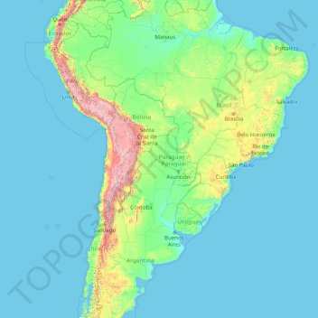
Name: South America topographic map, elevation, terrain.
Location: South America (-46.00022 -86.00066 3.99978 -36.00066)
Average elevation: 283 m
Minimum elevation: -1 m
Maximum elevation: 6,497 m
Make a donation
Other topographic maps
Click on a map to view its topography, its elevation and its terrain.
Philippines
The Philippines is an archipelago of approximately 7,641 islands, with a total land area of about 300,000 square kilometers. The terrain is predominantly mountainous, with narrow coastal plains and valleys. The highest peak is Mount Apo on Mindanao, reaching 2,954 meters (9,692 feet) above sea level. Other…
Average elevation: 33 m
Wisconsin
Wisconsin's topography is characterized by a diverse landscape shaped by glacial activity, resulting in a mixture of rolling hills, flat plains, and numerous lakes. The state’s highest point is Timms Hill, reaching an elevation of 1,952 feet (595 meters), while its lowest point is the shore of Lake Michigan…
Average elevation: 301 m
Laguna
Laguna is home to 24 mountains, most of which are inactive volcanoes. The highest peak in Laguna is Mt. Banahaw, with an elevation of 2,170 m (7,120 ft). Banahaw, unlike most other volcanoes in Laguna, is an active complex stratovolcano, which last erupted in 1843. Banahaw is located in the boundary of Laguna…
Average elevation: 183 m
Batangas
Batangas is a combination of plains and mountains, including one of the world's smallest volcanoes, Mt. Taal, with an elevation of 600 metres (2,000 ft), located in the middle of the Taal Lake. Other important peaks are Mount Macolod with an elevation of 830 metres (2,720 ft), Mt. Banoy with 960 metres (3,150…
Average elevation: 126 m
Make a donation
Bataan
Bataan is divided by two mountain groups of volcanic origins. The northern side is composed of the Mount Natib (elevation 1,253 metres (4,111 ft)), Mount Sta. Rosa and Mount Silangan. The southern group is composed of Mount Mariveles, Mount Samat, and Mount Cuyapo. A narrow pass separates these two mountain…
Average elevation: 70 m
Cavite
Another theory proposes that the name is a Hispanicized form of kabit, Tagalog for "joined", "connected", or "attached", referring to the peninsula's topographical relation to the mainland. Edmund Roberts, in his 1821 memoir, stated that the "natives" called it Caveit due to the "crooked point of land…
Average elevation: 88 m
Quezon City
In order to make Quezon's dream a reality and to mobilize funds for the land purchase, the People's Homesite Corporation (PHC) was created on October 14, 1938, as a subsidiary of NDC, with an initial capital of ₱2 million. Roces was the chairman of the Board of PHC, and they immediately acquired the vast…
Average elevation: 39 m
Make a donation
San Jose del Monte
The elevation of the city ranges from approximately 40 to 900 meters (130 to 2,950 ft) above sea level; the relief transitions from warm lowland to cool upland as one goes eastward. This is because the city is part of the Sierra Madre mountain range. Plains and river valley flats characterize the western and…
Average elevation: 73 m
Make a donation
Palawan
Palawan's almost 2,000 kilometers (1,200 mi) of irregular coastline is lined with rocky coves and sugar-white sandy beaches. It also harbors a vast stretch of virgin forests that carpet its chain of mountain ranges. The mountain heights average 1,100 meters (3,500 ft) in altitude, with the highest peak rising…
Average elevation: 44 m
Suffolk County
The highest elevation in the county, and on Long Island as a whole, is Jayne's Hill in West Hills, at 401 feet (122 m) above sea level.
Average elevation: 34 m
Make a donation
Dasmariñas
Dasmariñas is partly lowland and partly hilly. The Poblacion itself is elevated. From an elevation of 80 meters (260 ft) at the Poblacion, the land rises to 250 meters (820 ft) towards Silang. Generally, land near rivers and creeks are rugged. Dasmariñas is outside the typhoon belt and has no fault line…
Average elevation: 126 m
Zamboanga City
The overall topography of the city could be described as rolling to very steep. There are some flat lands, mostly narrow strips along the east coast. The urban center is mostly flat with a gentle slope to the interior, ranging from 0% to 3%. A portion, about 38,000 hectares, has slopes ranging from 18% to 30%.…
Average elevation: 78 m
Cebu
Coal was first discovered in Cebu about 1837. There were 15 localities over the whole island, on both coasts; some desultory mining had been carried out Naga near Mount Uling, but most serious operations were at Licos and Camansi west of Compostela and Danao. Active work ceased about 1895 with insurrections,…
Average elevation: 91 m
Make a donation
Isabela
The province is divided into three physiographic areas. The eastern area, straddled by the Sierra Madre mountain range, is rugged and thickly forested. A substantial portion is uncharted. These unexplored hinterlands are home to a rich variety of flora and fauna, and some are under government reservations. It…
Average elevation: 227 m
Make a donation
Taytay
The shape of Taytay is rectangular – trapezoidal with gently hilly rolling terrain on its eastern side while relatively flat on its south-western side, including the poblacion. The municipality's highest elevation ranges from 200 to 255 meters which is situated along the inner north-eastern hills of Barangay…
Average elevation: 37 m
Cagayan de Oro
Cagayan de Oro, located along the north-central coast of Mindanao, Philippines, encompasses a diverse topography that significantly influences its terrain. The city spans approximately 488.86 square kilometers (188.75 square miles), featuring a 25-kilometer (16 miles) coastline along Macajalar Bay. The…
Average elevation: 224 m
Pangantucan
Pangantucan is characterized by hilly and mountainous areas. To its north-west portion is Mount Kalatungan, the second highest peak in Bukidnon with an elevation of 2,824 metres (9,265 ft).
Average elevation: 743 m
Make a donation
Kabacan
The landscape is characterized by almost regular landscape of flat terrain. The high mountains and rolling hills leaping close to the river plus the narrow plains have varied topographical features. Other features are moderately sloping and strongly sloping.
Average elevation: 95 m
Malaybalay
The average elevation of the city is 622 metres (2,041 ft) above sea level. About 60% of the city's area has above 30% slope, characterized by steep hills, mountains, and cliff-like stream side. About 25% are level, gently sloping, and undulating. The rest are rolling and hilly.
Average elevation: 851 m
Make a donation
Dumaguete
As a coastal city, it is bounded on the east by the Bohol Sea and the Tañon Strait, serving as a natural border of southeastern Negros Island Region to the neighboring Central Visayas. The city's topography is generally flat from two to six kilometers from the shoreline. It slopes gently upwards to the…
Average elevation: 56 m
Make a donation
Masbate
The general surface configuration of the province ranges from slightly undulating to rolling and from hilly to mountainous. In each island, the rugged topography is concentrated in the northeastern portion and gradually recedes to blunt hills and rolling areas in the south, southeast, and southwest.
Average elevation: 28 m
Bukidnon
Situated within Bukidnon is Mount Dulang-dulang, the 2nd highest mountain in the country, with an elevation of 2,938 metres (9,639 ft) located in the Kitanglad Mountain Range. Mount Kitanglad (2,899 m), Mount Kalatungan (2,860 m), Mount Maagnaw (2,742 m), Mount Lumuluyaw (2,612 m), and Mount Tuminungan (2,400…
Average elevation: 686 m
Make a donation
Calbayog
Forty percent of the city's land area are plain and hilly terrains with elevation ranging from 5 to 20 metres (16 to 66 ft) above sea level. The rest are rugged mountain ranges with elevations from 300 to 700 metres (980 to 2,300 ft) above sea level. Flooding is minimized because of many rivers, brooks,…
Average elevation: 78 m
Imus
A second version is a rationalization of a geographical fact. Some intellectuals of the city theorized that the name "Imus" originated from the Latin word infimus, meaning lowland. Comparing the altitude of different towns in Cavite province, Imus is described as lowland, slowly elevating to the neighboring…
Average elevation: 26 m
Candon
Candon City is situated in the lower central portion of the Province of Ilocos Sur. It has a "C" shape with elevations ranging from 10 – 500 ft above sea level. The city is 346 kilometres (215 mi) from Metro Manila and 61 kilometres (38 mi) from Vigan City, the provincial capital.
Average elevation: 82 m
Angeles
Sapangbato is the largest barangay in Angeles in terms of territory, with a total land area of 104,694 sq. meters and a population of 11,262. Located northwest of Angeles near Clark Freeport Zone, it is identified as the barangay in Angeles with the highest elevation of 750 feet above sea level. It is home to…
Average elevation: 98 m
Make a donation
Make a donation
British Columbia
The Southern Interior cities of Kamloops and Penticton have some of the warmest and longest summer climates in Canada (while higher elevations are cold and snowy), although their temperatures are often exceeded north of the Fraser Canyon, close to the confluence of the Fraser and Thompson rivers, where the…
Average elevation: 708 m
Batangas City
The city is the center of the radio listening market in Batangas, and is served by local radio stations, as well as some radio stations from Lipa and other parts of the Mega Manila area. The Roman Catholic Archdiocese of Lipa, through the Radyo Bayanihan System, hosts two local radio stations: ALFM 95.9 Radyo…
Average elevation: 65 m
Make a donation
Make a donation
Make a donation
Muntinlupa
There are three plausible origins of the name of the city: First, is its association with the thin topsoil in the area; second, residents, purportedly replying to a question by Spaniards in the 16th century what the name of their place was, said “Monte sa Lupa”—apparently mistaking the question for what…
Average elevation: 21 m
Catanduanes
The topography of Catanduanes Island is rugged and mountainous, becoming more pronounced towards the central portion of the island. Less than 10 percent of the land area has a slope gradient under 8 percent, mostly fractured and narrow strips of plains located along the coastal areas where most of the…
Average elevation: 35 m
Ilocos Sur
Ilocos Sur occupies the central section of the Ilocos Region in northern Luzon. It is bordered by Ilocos Norte to the north, Abra to the northeast, Mountain Province to the east, Benguet to the southeast, La Union to the south, and the South China Sea to the west. Its area of 2,596.00 square kilometres…
Average elevation: 468 m
Make a donation
Aklan
Mount Nausang, is formerly the highest peak in Aklan, standing at 5,190 ft (1,580 m), the discovery of Mount Timbaban is much higher, with an elevation of 5,830.1 ft (1,777.0 m) above sea level, Mount Timbaban is not considered as independent mountain, it is still part of Mount Madja-as sub-summit with only…
Average elevation: 94 m
Make a donation
Baybay
The climate is of Coronas Climate type IV, which is generally wet with no particularly discernible seasons. Its topography is generally mountainous in the eastern portion as it slopes down west towards the shore line. Generally an agricultural city, the common means of livelihood are farming and fishing. Some…
Average elevation: 157 m
Make a donation
Manito
Manito is located on the south-eastern tip of Albay, adjoining the south-eastern limit of Legazpi City. The west and NW coast of Manito lies along Poliqui Bay opposite the city of Legazpi. To the north and north-east coast of the municipality lies Albay Gulf. To the east and south of Manito is the province of…
Average elevation: 121 m
Make a donation
Iloilo
The province is divided into two distinct geographic regions; the highlands of the Central Panay Mountain Range on the western border and the lowland plains which account for a larger portion of the province. Small islands east of its northernmost tip also dot the Visayan Sea - of these, Pan de Azucar and…
Average elevation: 129 m
Laguna de Bay
Laguna de Bay (Spanish for "Lagoon/Lake of Bay"; Tagalog: Lawa ng Bay, [baɪ]), also known as Laguna Lake, is the largest lake in the Philippines. It is located southeast of Metro Manila, between the provinces of Laguna to the south and Rizal to the north. A freshwater lake, it has a surface area of 911–949…
Average elevation: 62 m
Mandaue
It is one of the two (the other one being the municipality of Consolacion) local government units located within the mainland Metro Cebu where the elevation of land is less than 100 m (330 ft).
Average elevation: 31 m
Make a donation
Indang
The topography of Indang is characterised by gently sloping or rolling terrain. Almost 40.36% of its total land area is within the slope grade of 3-8%, while 2,135 hectares is within the slope range of 8-15% which is characterised by undulating or sloping terrain.
Average elevation: 328 m
Make a donation
Camiguin
Camiguin Island is a pearl-shaped island with an area of approximately 238 km2 (92 sq mi). The island measures about 23 kilometres (14 mi) at its longest and 14.5 kilometres (9.0 mi) at its widest breadth. The island is mountainous with the highest elevation reaching over 5,000 ft (1,500 m). It is encircled by…
Average elevation: 35 m
Marinduque
The highest peak in Marinduque is Mount Malindig (formerly called Mt. Marlanga), a potentially active stratovolcano with an elevation of 1,157 metres (3,796 ft) above sea level, located at the southern tip of the island.
Average elevation: 38 m
Make a donation
Capiz
Capiz covers a total area of 2,594.64 square kilometres (1,001.80 sq mi) occupying the northeastern portion of Panay Island, and is one of the five provinces that compose the Western Visayas region. Mount Nangtud, is the highest mountain in Capiz with an elevation of 6,804 ft (2,074 m) located in the…
Average elevation: 123 m
Make a donation
Caraga
Father Saturnino Urios University, was founded by Caraga's most loved Spanish missionary, Fr. Saturnino Urios S.J. in 1990. The Commission on Higher Education (CHED) recognized Father Saturnino Urios University as one of the best schools in the region producing top notchers in national board examinations in…
Average elevation: 136 m
Make a donation
Make a donation