
Make a donation
Lanao del Sur topographic map
Click on the map to display elevation.
Make a donation
About this map
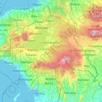
Name: Lanao del Sur topographic map, elevation, terrain.
Location: Lanao del Sur, Bangsamoro, Philippines (7.43907 123.84653 8.12367 124.82859)
Average elevation: 637 m
Minimum elevation: 0 m
Maximum elevation: 2,802 m
Make a donation
Other topographic maps
Click on a map to view its topography, its elevation and its terrain.
Vigan
Vigan is situated in a Quaternary Age sedimentary plain called the Vigan-Bantay Plain which is part of the Ilocos coastal plain. The Vigan-Bantay Plain is bounded on the east by a moderately rugged Miocene sediments consisting of interbedded sandstones and shale to very rugged Meta-volcanics and Meta sediment…
Average elevation: 63 m
Baguio
In 1903, Filipinos, Japanese and Chinese workers were hired to build Kennon Road, the first road directly connecting Baguio with the lowlands of La Union and Pangasinan. Before this, the only road to Benguet was Naguilian Road, and it was largely a horse trail at higher elevations. Camp John Hay was…
Average elevation: 881 m
Quezon City
Founded as a pueblo by Saint Pedro Bautista in 1590, San Francisco del Monte may be considered Quezon City's oldest district. The original land area of the old town of San Francisco del Monte was approximately2.5 square kilometres (1.0 sq mi) and covered parts of what is currently known as Project 7 and 8 and…
Average elevation: 57 m
Bacolod
Bacólod (English: Bacolod), is derived from bakólod (Old Spelling: bacólod), the Old Hiligaynon (Old Ilonggo) (Old Spelling: Ylongo and Ilongo) word for a "hill, turtle, mound, rise, hillock, down, any small eminence or elevation", since the resettlement was founded on a stony, hilly area, now the barangay…
Average elevation: 49 m
Make a donation
Valenzuela
The highest elevation point is 38 meters (125 ft) above sea level. Having a surface gradient of 0.55% and a gentle slope, hilly landscape is located in the industrial section of the city in Canumay. The average elevation point is 2 meters (6.6 ft) above sea level.
Average elevation: 24 m
Make a donation
Make a donation
San Juan
"San Juan" is a contraction of the city's traditional name of "San Juan del Monte" (lit. 'Saint John of the Mountain'). As with numerous other places in the Philippines, the name combines a patron saint and a toponym; in this case Saint John the Baptist with the locale's hilly terrain and relatively higher…
Average elevation: 35 m
Malolos
Malolos is relatively flat of about 0.81% to a gently sloping of 2.17%. The slope of the land descends towards west, southwest to southern direction. The highest land elevation is at about 6.0 meters above sea level while the lowest is only half a meter below sea level. A network of natural waterways and…
Average elevation: 6 m
Make a donation
Make a donation
La Mesa Dam
The La Mesa was built in Novaliches, which was then still part of the municipality of Caloocan due to the sloping topography of the watershed area from Bulacan. The La Mesa dam later became part of a larger dam system with the opening of the Ipo Dam in Norzagaray, Bulacan in 1936, the Angat Dam in the same…
Average elevation: 65 m
Make a donation
Montalban
Philippines > Rizal > Rodriguez
Rodriguez is generally very rough in topography, with 83% of its total land area composed of upland areas, hills and mountain ranges. The remaining 17% low-lying terrain and rolling lands are found at the south-western portion of the municipality, along with the northern portions of the Municipality of San…
Average elevation: 99 m
Make a donation
Make a donation
Make a donation
Make a donation
Make a donation
Make a donation
Dasmariñas
Dasmariñas is partly lowland and partly hilly. The Poblacion itself is elevated. From an elevation of 80 meters (260 ft) at the Poblacion, the land rises to 250 meters (820 ft) towards Silang. Generally, land near rivers and creeks are rugged. Dasmariñas is outside the typhoon belt and has no fault line…
Average elevation: 97 m
Make a donation
Catubig
Another tale was mentioned that the name Catubig was also a product of a 'word compact' between Americans and Filipinos. It was stated that an American surveyors saw a cat sunbathing by rolling along the grassy edge of the brook. They then approached a young lady who was doing her laundry and asked, “What is…
Average elevation: 41 m
Make a donation
Make a donation
Calabanga
The topographic landscape of the municipality could be characterized as generally flat with a slope 0-3%, gently sloping (3-8%) towards the direction of the eastern portion and finally rolling up to higher steeps towards the direction of the south-eastern part going to Mt. Isarog. The 0-3% slope is a broad…
Average elevation: 11 m
Zamboanga City
Philippines > Zamboanga Peninsula > Zamboanga City
The overall topography of the city could be described as rolling to very steep. There are some flat lands, mostly narrow strips along the east coast. The urban center is mostly flat with a gentle slope to the interior, ranging from 0 to 3%. The highest registered elevation is 1,200 metres. In terms of slope, a…
Average elevation: 83 m
Make a donation
Make a donation
Make a donation
Make a donation
Make a donation
Make a donation
Make a donation
Make a donation
Make a donation
Make a donation