
Calbayog topographic map
Click on the map to display elevation.
Calbayog
Forty percent of the city's land area are plain and hilly terrains with elevation ranging from 5 to 20 metres (16 to 66 ft) above sea level. The rest are rugged mountain ranges with elevations from 300 to 700 metres (980 to 2,300 ft) above sea level. Flooding is minimized because of many rivers, brooks, streams and natural water conveyors that flow towards the sea.
About this map
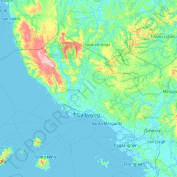
Name: Calbayog topographic map, elevation, terrain.
Location: Calbayog, Samar, Eastern Visayas, 6710, Philippines (11.96533 124.24146 12.33939 124.84262)
Average elevation: 78 m
Minimum elevation: -2 m
Maximum elevation: 653 m
Other topographic maps
Click on a map to view its topography, its elevation and its terrain.
Pinabacdao
For administrative and statistical convenience, barangays are group into two districts - the Pinabacdao East District and Pinabacdao West District. The East district is composed of barangays situated in high altitude areas or those located in the eastern part of the municipality. Barangays located along…
Average elevation: 11 m
Silanga District of Catbalogan City
Philippines > Samar > Silanga District of Catbalogan City
Average elevation: 21 m
Calbayog
Philippines > Samar > Calbayog
Forty percent of the city's land area are plain and hilly terrains with elevation ranging from 5 to 20 metres (16 to 66 ft) above sea level. The rest are rugged mountain ranges with elevations from 300 to 700 metres (980 to 2,300 ft) above sea level. Flooding is minimized because of many rivers, brooks,…
Average elevation: 55 m