
Burias topographic map
Click on the map to display elevation.
About this map
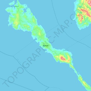
Name: Burias topographic map, elevation, terrain.
Location: Burias, Masbate, Bicol Region, 5420, Philippines (12.69359 122.92824 13.15915 123.38610)
Average elevation: 18 m
Minimum elevation: 0 m
Maximum elevation: 490 m
Other topographic maps
Click on a map to view its topography, its elevation and its terrain.
Cawayan
The locals of Cawayan still largely depend on subsistence farming despite its topographic advantage to adapt commercial farming. The lack of funding for agriculture and infrastructure and its political insecurity due to the presence and activities of armed groups kept by political families and other subversive…
Average elevation: 12 m
Jintotolo Island
Philippines > Masbate > Jintotolo
Its elevation was recorded at around 120 feet (37 m) in 1919. A lighthouse with a tower at 51 feet (16 m) in height exists on Jintotolo island.
Average elevation: 6 m
Mandaon
Mandaon was originally a barrio of Milagros, established by Barrio Lieutenant Feliciano Aquillo Sr. In 1948, Juan Valencia, a settler from Pampanga, advocated for its elevation into a municipality. On July 18, 1949, President Elpidio Quirino, through Executive Order No. 244, officially recognized Mandaon as an…
Average elevation: 18 m
Cawayan
The locals of Cawayan still largely depend on subsistence farming despite its topographic advantage to adapt commercial farming. The lack of funding for agriculture and infrastructure and its political insecurity due to the presence and activities of armed groups kept by political families and other subversive…
Average elevation: 12 m