
Silanga topographic map
Interactive map
Click on the map to display elevation.
About this map
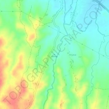
Name: Silanga topographic map, elevation, terrain.
Location: Silanga, Situbondo, East Java, Indonesia (-7.73338 114.11662 -7.73328 114.11672)
Average elevation: 37 m
Minimum elevation: 9 m
Maximum elevation: 75 m
Other topographic maps
Click on a map to view its topography, its elevation and its terrain.
Penanggungan
Indonesia > East Java > Mojokerto > Penanggungan
Penanggungan, Mojokerto, East Java, Indonesia
Average elevation: 645 m
Gunung Lawu
Indonesia > East Java > Madiun
Gunung Lawu, Madiun, East Java, Indonesia
Average elevation: 2,881 m