
Make a donation
Innsbruck topographic map
Click on the map to display elevation.
Make a donation
About this map
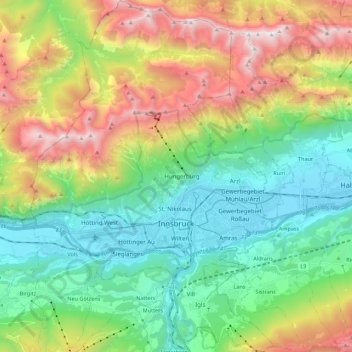
Name: Innsbruck topographic map, elevation, terrain.
Location: Innsbruck, Tyrol, Austria (47.21077 11.30164 47.36013 11.45596)
Average elevation: 1,280 m
Minimum elevation: 558 m
Maximum elevation: 2,668 m
Make a donation
Other topographic maps
Click on a map to view its topography, its elevation and its terrain.
Make a donation
Make a donation
Make a donation
Make a donation
Hoher Burgstall
Austria > Tyrol > Bezirk Innsbruck-Land > Neustift im Stubaital
Average elevation: 2,142 m
Make a donation
Make a donation
Make a donation
Make a donation
Make a donation
Make a donation
Make a donation
Make a donation
Elferspitze
Austria > Tyrol > Bezirk Innsbruck-Land > Neustift im Stubaital
Average elevation: 1,978 m
Make a donation
Make a donation
Make a donation
Make a donation
Make a donation
Oberlängenfeld
Austria > Tyrol > Bezirk Imst > Gemeinde Längenfeld > Längenfeld
Average elevation: 1,584 m
Make a donation
Make a donation
Make a donation
Unterlängenfeld
Austria > Tyrol > Bezirk Imst > Gemeinde Längenfeld > Längenfeld
Average elevation: 1,590 m
Make a donation
Axamer Lizum
Austria > Tyrol > Bezirk Innsbruck-Land > Gemeinde Axams > Axamer Lizum
Average elevation: 1,858 m
Pettneu am Arlberg
Austria > Tyrol > Bezirk Landeck > Gemeinde Pettneu am Arlberg > Pettneu am Arlberg
Average elevation: 1,614 m
Make a donation
Make a donation
Salzbodensee
Austria > Tyrol > Bezirk Lienz > Marktgemeinde Matrei in Osttirol
Average elevation: 2,250 m
Make a donation
Bobojach
Austria > Tyrol > Bezirk Lienz > Gemeinde Prägraten am Großvenediger
Average elevation: 1,728 m