
Make a donation
Madau topographic map
Click on the map to display elevation.
Make a donation
About this map
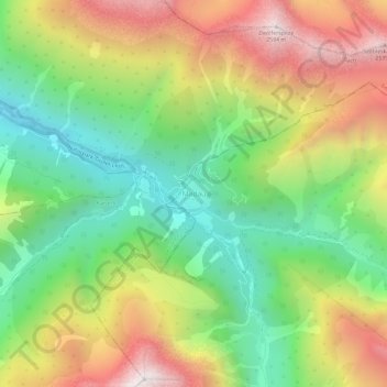
Name: Madau topographic map, elevation, terrain.
Location: Madau, Zams, Bezirk Landeck, Tyrol, 6511, Austria (47.21354 10.43246 47.25354 10.47246)
Average elevation: 1,780 m
Minimum elevation: 1,169 m
Maximum elevation: 2,589 m
Make a donation
Other topographic maps
Click on a map to view its topography, its elevation and its terrain.
Ischgl
Austria > Tyrol > Bezirk Landeck
Ischgl has a weather station at an altitude of 2,327 m (7,635 ft). This weather station is located within the alpine climate zone (Köppen ETH), closely bordering on a subarctic climate (Köppen Dfc), because the hottest month is only 9.9 °C (49.8 °F).
Average elevation: 2,251 m
Make a donation
Make a donation
Nauders
Austria > Tyrol > Bezirk Landeck
The town lies in the valley of the Stillebach (a tributary of the Inn) in the Ötztal Alps, at an altitude of 1,394 m (4,573 ft). It is located about 29 km (18 mi) south of the district capital Landeck, on the road that leads from Pfunds in the Inntal valley via the narrow Finstermünz Gorge up to Reschen Pass…
Average elevation: 1,938 m
Ischgl
Austria > Tyrol > Bezirk Landeck
Ischgl has a weather station at an altitude of 2,327 m (7,635 ft). This weather station is located within the alpine climate zone (Köppen ETH), closely bordering on a subarctic climate (Köppen Dfc), because the hottest month is only 9.9 °C (49.8 °F).
Average elevation: 2,251 m
Make a donation
Kaunertal
Austria > Tyrol > Bezirk Landeck
The Kaunertal valley is 28 km (17 mi) in length and runs southeast from the town of Prutz (884 m) to the Kaunertal Glacier. The valley is traversed by the Faggenbach river, which rises south of the Weißseespitze mountain (3044 m) and flows into the Inn river at Prutz (884 m), the site of a hydroelectric power…
Average elevation: 2,399 m
Make a donation
Nauders
Austria > Tyrol > Bezirk Landeck
The town lies in the valley of the Stillebach (a tributary of the Inn) in the Ötztal Alps, at an altitude of 1,394 m (4,573 ft). It is located about 29 km (18 mi) south of the district capital Landeck, on the road that leads from Pfunds in the Inntal valley via the narrow Finstermünz Gorge up to Reschen Pass…
Average elevation: 1,938 m
Ischgl
Austria > Tyrol > Bezirk Landeck
Ischgl has a weather station at an altitude of 2,327 m (7,635 ft). This weather station is located within the alpine climate zone (Köppen ETH), closely bordering on a subarctic climate (Köppen Dfc), because the hottest month is only 9.9 °C (49.8 °F).
Average elevation: 2,251 m
Make a donation