
Guanajuato topographic map
Interactive map
Click on the map to display elevation.
About this map
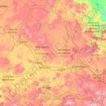
Name: Guanajuato topographic map, elevation, terrain.
Location: Guanajuato, Mexico (19.91275 -102.09728 21.83942 -99.67130)
Average elevation: 2,005 m
Minimum elevation: 873 m
Maximum elevation: 3,508 m
Guanajuato is in the center of Mexico, northwest of Mexico City, bordering Zacatecas, San Luis Potosí, Michoacán, Querétaro, and Jalisco. It is the 20th-largest of Mexico's states, with an area of 30,589 km². It has an average altitude of 2,015 meters (6,611 ft) above sea level, with its territory divided among three of Mexico's physical regions, the Sierra Madre Oriental, the Mexican Plateau and the Trans-Mexican Volcanic Belt. The Sierra Madre Oriental in Guanajuato consists of the Sierra Gorda and the Sierra del Azafrán in the northeast. The Mexican Plateau extends through the center of the state. It is subdivided into various regions parted by low-lying mountain chains such as the Sierra de la Cuatralba and the Sierra de Cubo. The Trans Mexican Volcanic Belt crosses the state in the south and includes the Bajío area, the Altos de Jalisco and the valleys area in the far south. The state is crossed by several mountain ranges with mountains between 2,300 and 3,000 meters high. Mountain ranges average 2,305 meters and flat areas lie at around 1,725 meters above mean sea level. Other important mountain ranges include the Sierra Gorda to the north, the Sierra de Guanjuato in the southeast, the Comanja in the northwest and the Codorniz in the east.
Other topographic maps
Click on a map to view its topography, its elevation and its terrain.
San José el Verde
San José el Verde, El Salto, Región Centro, Jalisco, 45694, Mexico
Average elevation: 1,551 m
San Felipe
Mexico > Baja California > Municipio de San Felipe
San Felipe, Municipio de San Felipe, Baja California, 21079, Mexico
Average elevation: 34 m
La Casa de Piedra
Mexico > Sonora > Villa Hidalgo
La Casa de Piedra, Villa Hidalgo, Sonora, Mexico
Average elevation: 726 m
Acapulco
Mexico > Guerrero > Acapulco de Juárez
Acapulco, Acapulco de Juárez, Guerrero, 39300, Mexico
Average elevation: 99 m
San Quintín
Mexico > Baja California > Municipio de San Quintín
San Quintín, Municipio de San Quintín, Baja California, 22932, Mexico
Average elevation: 36 m
Tepetiltic
Mexico > Nayarit > San Pedro Lagunillas
Tepetiltic, San Pedro Lagunillas, Nayarit, Mexico
Average elevation: 1,520 m
Naucalpan de Juárez
Naucalpan de Juárez, State of Mexico, Mexico
Average elevation: 2,366 m
Nezahualcóyotl
Nezahualcóyotl, State of Mexico, Mexico
Average elevation: 2,235 m
Malibu
Mexico > Chiapas > Tuxtla Gutiérrez > Terán
Malibu, Terán, Tuxtla Gutiérrez, Chiapas, 29025, Mexico
Average elevation: 645 m
Santa Rosa Jauregui
Mexico > Querétaro > Municipio de Querétaro
Santa Rosa Jauregui, Municipio de Querétaro, Querétaro, Mexico
Average elevation: 1,979 m
Villa del Río
Mexico > Veracruz > Manlio Fabio Altamirano
Villa del Río, Manlio Fabio Altamirano, Veracruz, Mexico
Average elevation: 45 m
Santa Maria
Mexico > Chihuahua > Namiquipa > El Terrero
Santa Maria, El Terrero, Namiquipa, Chihuahua, Mexico
Average elevation: 1,936 m
Durango
Mexico > Durango > Municipio de Durango > Durango
Durango, Municipio de Durango, Durango, Mexico
Average elevation: 1,936 m
Lázaro Cárdenas
Mexico > Michoacán > Lázaro Cárdenas > Lázaro Cárdenas
Lázaro Cárdenas, Michoacán, 60950, Mexico
Average elevation: 42 m
Matamoros
Mexico > Tamaulipas > Matamoros
Matamoros, Municipio de Matamoros, Tamaulipas, 87457, Mexico
Average elevation: 9 m
San Juan la Unión
Mexico > Oaxaca > San Lucas Zoquiápam
San Juan la Unión, San Lucas Zoquiápam, Oaxaca, Mexico
Average elevation: 1,750 m
Ensenada
Mexico > Baja California > Municipio de Ensenada
Ensenada, Municipio de Ensenada, Baja California, Mexico
Average elevation: 184 m
Rincón de Romos
Mexico > Aguascalientes > Rincón de Romos
Rincón de Romos, Aguascalientes, 20603, Mexico
Average elevation: 1,981 m
Ecatepec de Morelos
Ecatepec de Morelos, State of Mexico, Mexico
Average elevation: 2,288 m
Cabo San Lucas
Mexico > South Lower California > Cabo San Lucas
Cabo San Lucas, Los Cabos, South Lower California, 23470, Mexico
Average elevation: 94 m
Tlaltenango de Sánchez Román
Tlaltenango de Sánchez Román, Zacatecas, Mexico
Average elevation: 2,037 m