
Make a donation
Puebla topographic map
Click on the map to display elevation.
Make a donation
Puebla
Most of the mountains of Puebla belong to the Sierra Madre Oriental and the Trans-Mexican Volcanic Belt. The first is locally called the Sierra Norte del Puebla, entering the state from the northwest and then breaks up into the smaller chains of Sierra de Zacapoaxtla, Sierra de Huauchinango, Sierra de Teziutlán, Sierra de Tetela de Ocampo, Sierra de Chignahuapan and Sierra de Zacatlán, although these names may vary among localities. Some of the highest elevations include Apulco, Chichat, Chignahuapan, Soltepec and Tlatlaquitepec. The highest elevations are the volcanoes Pico de Orizaba or Citlaltepetl (5,747masl), Popocatépetl (5,452masl), Iztaccíhuatl (5,286masl) and Malinche (4,461masl) which are found on the state's borders with Veracruz, Mexico State and Tlaxcala respectively. In the south of the state, the major elevations are the Sierra de Atenahuacán, Zapotitlán, Lomerio al Suroeste and the Sierra de Tehuacán. Dividing much of the state from Veracruz is a small chain of mountains called the Sierra Madre del Golfo.
Make a donation
About this map
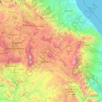
Name: Puebla topographic map, elevation, terrain.
Location: Puebla, Mexico (17.86091 -99.07049 20.83963 -96.72462)
Average elevation: 1,532 m
Minimum elevation: 0 m
Maximum elevation: 5,520 m
Make a donation
Other topographic maps
Click on a map to view its topography, its elevation and its terrain.
Make a donation
Villahermosa
Villahermosa is located in the southeast of Mexico between the rivers Grijalva and Carrizal. The average elevation of the city is 10 meters above sea level. The city also has several lagoons, the largest and most important of them being La Laguna de las Ilusiones (Illusions Lagoon).
Average elevation: 9 m
Make a donation
Acapulco
Mexico > Guerrero > Acapulco de Juárez
The city, located on the Pacific coast of Mexico in the state of Guerrero, is classified as one of the state's seven regions, dividing the rest of the Guerrero coast into the Costa Grande and the Costa Chica. Forty percent of the municipality is mountainous terrain; another forty percent is semi-flat; and the…
Average elevation: 99 m
Ciudad Juárez
Due to its location in the Chihuahuan Desert and high altitude, Ciudad Juárez has a cold desert climate (Köppen: BWk). Seasons are distinct, with hot summers, mild springs and autumns, and cold winters. Summer average high is 35 °C (95 °F) with lows of 21 °C (70 °F). Winter highs average 14 °C (57 °F)…
Average elevation: 1,228 m
Make a donation
Make a donation
Make a donation
Make a donation