
Jilotepec topographic map
Interactive map
Click on the map to display elevation.
About this map
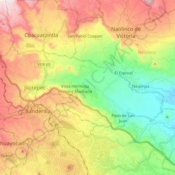
Name: Jilotepec topographic map, elevation, terrain.
Location: Jilotepec, Veracruz, Mexico (19.57862 -96.98782 19.64367 -96.84145)
Average elevation: 1,357 m
Minimum elevation: 809 m
Maximum elevation: 2,038 m
Other topographic maps
Click on a map to view its topography, its elevation and its terrain.
Villa del Río
Mexico > Veracruz > Manlio Fabio Altamirano
Villa del Río, Manlio Fabio Altamirano, Veracruz, Mexico
Average elevation: 45 m
El Chichón
Mexico > Veracruz > El Chichón
El Chichón, Las Choapas, Veracruz, Mexico
Average elevation: 44 m
El Vizcaíno
Mexico > Veracruz > El Vizcaíno
El Vizcaíno, Coatzintla, Veracruz, Mexico
Average elevation: 123 m
San Lorenzo Tenochtitlán
Mexico > Veracruz > San Lorenzo Tenochtitlán
San Lorenzo Tenochtitlán, Texistepec, Veracruz, Mexico
Average elevation: 10 m