
Thank you for supporting this site ❤️
Make a donation
Make a donation
Ahumada topographic map
Click on the map to display elevation.
Thank you for supporting this site ❤️
Make a donation
Make a donation
Ahumada
Carrizal is a rural community located in Ahumada Municipality, Chihuahua, Mexico. It had a population of 102 inhabitants at the 2010 census, and is situated at an elevation of 1,120 meters above sea level.
Thank you for supporting this site ❤️
Make a donation
Make a donation
About this map
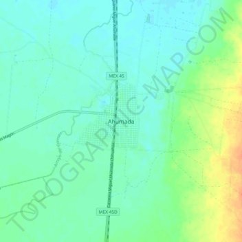
Name: Ahumada topographic map, elevation, terrain.
Location: Ahumada, Chihuahua, Mexico (30.57285 -106.55240 30.65285 -106.47240)
Average elevation: 1,204 m
Minimum elevation: 1,194 m
Maximum elevation: 1,227 m
Thank you for supporting this site ❤️
Make a donation
Make a donation