
Make a donation
Michoacán topographic map
Click on the map to display elevation.
Make a donation
Michoacán
Much of the climate of the state is determined by altitude and other geographical features. Average temperatures vary from 13 °C (55 °F) to 29 °C (84 °F). Lower temperatures correspond with the highland areas in the north and east while the lower south and west, called La Costa (the coast) or Tierra Caliente (hot land) register higher temperatures. In the hotter lowlands, high temperatures regularly exceed 30 °C (86 °F) and have been known to reach over 40 °C (104 °F) in the summer. The lowest temperatures are registered in highland areas such as the Sierra de Coalcomán and the Sierra del Centro located near the border with the State of Mexico. Except for the Tierra Caliente, most of the state can experience freezing temperatures in the winter. Rainfall is also dependent on altitude with the lowlands receiving less rain than the mountain areas. There is a well-defined rainy season which extends from June to October over the entire state.
Make a donation
About this map
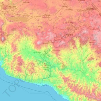
Name: Michoacán topographic map, elevation, terrain.
Location: Michoacán, Mexico (17.91491 -103.73905 20.39452 -100.06303)
Average elevation: 1,239 m
Minimum elevation: 0 m
Maximum elevation: 3,919 m
Make a donation
Other topographic maps
Click on a map to view its topography, its elevation and its terrain.
Make a donation
Villahermosa
Villahermosa is located in the southeast of Mexico between the rivers Grijalva and Carrizal. The average elevation of the city is 10 meters above sea level. The city also has several lagoons, the largest and most important of them being La Laguna de las Ilusiones (Illusions Lagoon).
Average elevation: 9 m
Make a donation
Acapulco
Mexico > Guerrero > Acapulco de Juárez
The city, located on the Pacific coast of Mexico in the state of Guerrero, is classified as one of the state's seven regions, dividing the rest of the Guerrero coast into the Costa Grande and the Costa Chica. Forty percent of the municipality is mountainous terrain; another forty percent is semi-flat; and the…
Average elevation: 99 m
Ciudad Juárez
Due to its location in the Chihuahuan Desert and high altitude, Ciudad Juárez has a cold desert climate (Köppen: BWk). Seasons are distinct, with hot summers, mild springs and autumns, and cold winters. Summer average high is 35 °C (95 °F) with lows of 21 °C (70 °F). Winter highs average 14 °C (57 °F)…
Average elevation: 1,228 m
Make a donation
Make a donation
Make a donation
Make a donation