
Make a donation
Jambi topographic map
Click on the map to display elevation.
Make a donation
Jambi
The total land area of Jambi city is 169.887 km2 (66 sq mi). Jambi city is located in the southwestern portion of the Sumatran Basin, a low-lying area in Eastern Sumatra with an altitude of 0 to 60m above sea level. A segment of the Batang Hari River, the longest river in Sumatra at 1,700 km (1,056 mi), flows through Jambi City.
Make a donation
About this map
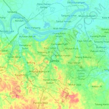
Name: Jambi topographic map, elevation, terrain.
Location: Jambi, Sumatra, Indonesia (-1.69613 103.52422 -1.54667 103.68106)
Average elevation: 22 m
Minimum elevation: 3 m
Maximum elevation: 64 m
Make a donation
Other topographic maps
Click on a map to view its topography, its elevation and its terrain.
Mount Kerinci
Mount Kerinci (Kerinci: Gunung Kincai, Minangkabau: Gunuang Kurinci, Indonesian: Gunung Kerinci), also spelled Kerintji, is an active stratovolcano and the highest mountain in Sumatra, Indonesia. At 12,484 ft (3,805 m) above sea level, it provides Sumatra with the fifth-highest maximum elevation of any island…
Average elevation: 3,229 m
Make a donation
Make a donation
Make a donation
Make a donation
Make a donation
Make a donation
Make a donation
Make a donation
Make a donation
Make a donation
Make a donation
Make a donation
Make a donation