
Thank you for supporting this site ❤️
Make a donation
Make a donation
Pemayung topographic map
Click on the map to display elevation.
Thank you for supporting this site ❤️
Make a donation
Make a donation
About this map
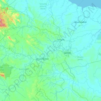
Name: Pemayung topographic map, elevation, terrain.
Location: Pemayung, Jambi, Indonesia (-2.30090 102.67567 -0.90090 104.07567)
Average elevation: 35 m
Minimum elevation: -2 m
Maximum elevation: 642 m
Thank you for supporting this site ❤️
Make a donation
Make a donation
Other topographic maps
Click on a map to view its topography, its elevation and its terrain.
Thank you for supporting this site ❤️
Make a donation
Make a donation
Thank you for supporting this site ❤️
Make a donation
Make a donation
Thank you for supporting this site ❤️
Make a donation
Make a donation
Jambi
The total land area of Jambi city is 169.887 km2 (66 sq mi). Jambi city is located in the southwestern portion of the Sumatran Basin, a low-lying area in Eastern Sumatra with an altitude of 0 to 60m above sea level. A segment of the Batang Hari River, the longest river in Sumatra at 1,700 km (1,056 mi), flows…
Average elevation: 22 m
Thank you for supporting this site ❤️
Make a donation
Make a donation
Thank you for supporting this site ❤️
Make a donation
Make a donation