
Quezon City topographic map
Interactive map
Click on the map to display elevation.
About this map
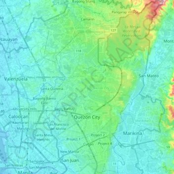
Name: Quezon City topographic map, elevation, terrain.
Average elevation: 39 m
Minimum elevation: -2 m
Maximum elevation: 252 m
In order to make Quezon's dream a reality and to mobilize funds for the land purchase, the People's Homesite Corporation (PHC) was created on October 14, 1938, as a subsidiary of NDC, with an initial capital of ₱2 million. Roces was the chairman of the Board of PHC, and they immediately acquired the vast Diliman Estate of the Tuason family at a cost of 5 centavos per square meter. PHC conducted topographical and subdivision surveys, and then subdivided the lots and sold them to the target buyers at an affordable price. Its target users and beneficiaries are obviously Manila's working class, who are suffering from the shortage of affordable and decent housing in the capital. The service of the Metropolitan Waterworks system was extended to site. The Bureau of Public Works, then under Secretary Vicente Fragante, constructed the streets and highways within the property. Quezon also tapped Architect Juan M. Arellano to draft a design of the city.
Other topographic maps
Click on a map to view its topography, its elevation and its terrain.
Cebu City
Philippines > Cebu > Cebu City
Cebu City, Cebu, Central Visayas, 6000, Philippines
Average elevation: 140 m
Dasmarinas
Philippines > Cavite > Dasmarinas > Buhi
Dasmarinas, Cavite, Calabarzon, 4114, Philippines
Average elevation: 114 m
Pulangbato
Philippines > Negros Oriental > Valencia
Pulangbato, Valencia, Negros Oriental, Central Visayas, 6215, Philippines
Average elevation: 474 m
Malolos
Malolos, Bulacan, Central Luzon, 3000, Philippines
Average elevation: 6 m
Las Piñas
Philippines > Las Piñas > Las Piñas
Las Piñas, Southern Manila District, Metro Manila, Philippines
Average elevation: 26 m
Mandaluyong
Mandaluyong, Eastern Manila District, Metro Manila, 1551, Philippines
Average elevation: 33 m
Taft
Taft, Eastern Samar, Eastern Visayas, 6816, Philippines
Average elevation: 17 m
Tacloban
Philippines > Leyte > Tacloban
Tacloban, Leyte, Eastern Visayas, 6500, Philippines
Average elevation: 29 m
Pasay
Pasay, Southern Manila District, Metro Manila, 1300, Philippines
Average elevation: 14 m
Tuguegarao
Tuguegarao, Cagayan, Cagayan Valley, 3500, Philippines
Average elevation: 49 m
Cagayan de Oro
Cagayan de Oro, Northern Mindanao, 9000, Philippines
Average elevation: 224 m
Rizal
Philippines > Quirino > Rizal
Rizal, Quirino, Cagayan Valley, Philippines
Average elevation: 130 m
Tagum
Tagum, Davao del Norte, Davao Region, 8100, Philippines
Average elevation: 103 m
Lubuagan
Lubuagan, Kalinga, Cordillera Administrative Region, Philippines
Average elevation: 809 m
Valencia
Philippines > Negros Oriental > Valencia
Valencia, Negros Oriental, Central Visayas, 6215, Philippines
Average elevation: 250 m
Quezon City
Quezon City, Eastern Manila District, Metro Manila, Philippines
Average elevation: 57 m
Baguio
Baguio, Cordillera Administrative Region, 2600, Philippines
Average elevation: 1,371 m
Taal Volcano
Philippines > Batangas > San Nicolas
Taal Volcano, San Nicolas, Batangas, Calabarzon, 4207, Philippines
Average elevation: 91 m
Bais
Bais, Negros Oriental, Central Visayas, 6206, Philippines
Average elevation: 177 m
Upper Quezon Hill
Upper Quezon Hill, District 16, Baguio, Cordillera Administrative Region, 2600, Philippines
Average elevation: 1,427 m
Tandag
Tandag, Surigao del Sur, Caraga, 8300, Philippines
Average elevation: 80 m
Bagabag
Bagabag, Nueva Vizcaya, Cagayan Valley, 3711, Philippines
Average elevation: 262 m
Natunuan
Philippines > Batangas > San Jose
Natunuan, San Jose, Batangas, Calabarzon, 4227, Philippines
Average elevation: 191 m
Canlaon
Canlaon, Negros Oriental, Central Visayas, 6223, Philippines
Average elevation: 432 m
San Fernando
San Fernando, La Union, Ilocos Region, 2500, Philippines
Average elevation: 81 m
Santa Rosa
Philippines > Laguna > Santa Rosa
Santa Rosa, Laguna, Calabarzon, 4026, Philippines
Average elevation: 65 m
Zamboanga City
Philippines > Zamboanga Peninsula > Zamboanga City
Zamboanga City, Zamboanga Peninsula, 7000, Philippines
Average elevation: 83 m