
Make a donation
North Dakota topographic map
Click on the map to display elevation.
Make a donation
About this map
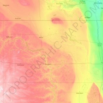
Name: North Dakota topographic map, elevation, terrain.
Location: North Dakota, United States (45.93505 -104.04927 49.00058 -96.55440)
Average elevation: 559 m
Minimum elevation: 229 m
Maximum elevation: 1,234 m
Make a donation
Other topographic maps
Click on a map to view its topography, its elevation and its terrain.
Make a donation
New York
United States > New York > New York County
The city's land has been altered substantially by human intervention, with considerable land reclamation along the waterfronts since Dutch colonial times; reclamation is most prominent in Lower Manhattan, with developments such as Battery Park City in the 1970s and 1980s. Some of the natural relief in…
Average elevation: 15 m
Make a donation
Make a donation
Make a donation
Sassafrass Natural Resource Management Area
United States > Maryland > Kent County > Knocks Folly
Average elevation: 14 m
Make a donation
Wood
United States > Pennsylvania > Bucks County > Bristol Township > Levittown
Average elevation: 15 m
Make a donation
Buford Horizons Mobile Home Park
United States > Georgia > Gwinnett County > Buford
Average elevation: 328 m
Make a donation
Sunny Rest Lodge
United States > Pennsylvania > Carbon County > Franklin Township
Average elevation: 237 m
Make a donation
Piʻiholo
United States > Hawaii > Maui County
Piʻiholo is a mountain summit on the island of Maui in Hawaii. It is at 20°51′7″N 156°17′33″W / 20.85194°N 156.29250°W / 20.85194; -156.29250 and has an elevation of 689 meters (2,260 feet).
Average elevation: 587 m
Make a donation
Mississippi River
United States > Illinois > Hancock County > Pontoosuc
The uppermost lock and dam on the Upper Mississippi River is the Upper St. Anthony Falls Lock and Dam in Minneapolis. Above the dam, the river's elevation is 799 feet (244 m). Below the dam, the river's elevation is 750 feet (230 m). This 49-foot (15 m) drop is the largest of all the Mississippi River locks…
Average elevation: 161 m
Make a donation
Make a donation
North Stelton
United States > New Jersey > Middlesex County > Piscataway Township
Average elevation: 29 m
Make a donation
Make a donation
Make a donation
Tiana
United States > New York > Suffolk County > Hampton Bays > Town of Southampton
Average elevation: 12 m
Frazer
United States > Pennsylvania > Chester County > East Whiteland Township
Average elevation: 142 m
Make a donation
Mount Shasta
United States > California > Siskiyou County
Mount Shasta (/ˈʃæstə/ SHASS-tə; Shasta: Waka-nunee-Tuki-wuki; Karuk: Úytaahkoo) is a potentially active volcano at the southern end of the Cascade Range in Siskiyou County, California. At an elevation of 14,179 ft (4,322 m), it is the second-highest peak in the Cascades and the fifth-highest in the…
Average elevation: 3,717 m
Great Plains
United States > Kansas > Thomas County
The North American Environmental Atlas, produced by the Commission for Environmental Cooperation, a North American Free Trade Agreement (NAFTA) agency composed of the geographical agencies of the Mexican, American, and Canadian governments, uses the "Great Plains" as an ecoregion synonymous with predominant…
Average elevation: 1,023 m
Make a donation
Make a donation
Make a donation
Make a donation
East Summit
United States > Connecticut > Northwest Hills Planning Region > Norfolk
Average elevation: 431 m
Make a donation
Make a donation
Rosewood Park
United States > Pennsylvania > Bucks County > Warminster Township
Average elevation: 88 m
Central Park
United States > New York > New York County > New York
In June 1856, Fernando Wood appointed a "consulting board" of seven people, headed by author Washington Irving, to inspire public confidence in the proposed development. Wood hired military engineer Egbert Ludovicus Viele as the park's chief engineer, tasking him with a topographical survey of the site. The…
Average elevation: 26 m
Make a donation
Live Oak
United States > California > Santa Cruz County
Live Oak is a census-designated place (CDP) in Santa Cruz County, California between the cities of Santa Cruz and Capitola and north of the former Union Pacific railroad. Live Oak sits at an elevation of 102 feet (31 m). The population was 17,038 at the 2020 census. The population of the greater Live Oak area,…
Average elevation: 50 m
Make a donation
Make a donation
Make a donation