
Parañaque topographic map
Click on the map to display elevation.
About this map
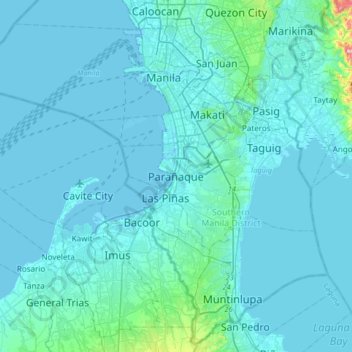
Name: Parañaque topographic map, elevation, terrain.
Location: Parañaque, Metro Manila, 1700, Philippines (14.34081 120.83153 14.66081 121.15153)
Average elevation: 14 m
Minimum elevation: -3 m
Maximum elevation: 234 m
Other topographic maps
Click on a map to view its topography, its elevation and its terrain.
Metro Manila
The Coastal Margin or Lowland is a flat and low plain that faces Manila Bay. Located here is Manila, Navotas, parts of Malabon, and the western part and reclaimed areas of Pasay and Parañaque, where the ground elevation ranges from zero meters on Manila Bay to five meters at the west side of the cities of…
Average elevation: 43 m
Quezon City
In order to make Quezon's dream a reality and to mobilize funds for the land purchase, the People's Homesite Corporation (PHC) was created on October 14, 1938, as a subsidiary of NDC, with an initial capital of ₱2 million. Roces was the chairman of the Board of PHC, and they immediately acquired the vast…
Average elevation: 39 m
Aurora
The province covers a portion of the Sierra Madre mountain range. As such, the elevation is generally steep to very steep and only about 14% of the province's total area is flat.
Average elevation: 255 m
Batangas
Batangas is a combination of plains and mountains, including one of the world's smallest volcanoes, Mt. Taal, with an elevation of 600 metres (2,000 ft), located in the middle of the Taal Lake. Other important peaks are Mount Macolod with an elevation of 830 metres (2,720 ft), Mt. Banoy with 960 metres (3,150…
Average elevation: 126 m
Cagayan de Oro
Cagayan de Oro, located along the north-central coast of Mindanao, Philippines, encompasses a diverse topography that significantly influences its terrain. The city spans approximately 488.86 square kilometers (188.75 square miles), featuring a 25-kilometer (16 miles) coastline along Macajalar Bay. The…
Average elevation: 224 m
Iloilo
The province is divided into two distinct geographic regions; the highlands of the Central Panay Mountain Range on the western border and the lowland plains which account for a larger portion of the province. Small islands east of its northernmost tip also dot the Visayan Sea - of these, Pan de Azucar and…
Average elevation: 129 m
Cavite
Another theory proposes that the name is a Hispanicized form of kabit, Tagalog for "joined", "connected", or "attached", referring to the peninsula's topographical relation to the mainland. Edmund Roberts, in his 1821 memoir, stated that the "natives" called it Caveit due to the "crooked point of land…
Average elevation: 88 m
Marawi
Marawi is located upon the shores of Lake Lanao. It is primarily inhabited by the Maranao people. The city is also called the "Summer Capital of the South" due to its higher elevation and cooler climate, a nickname it shares with Malaybalay.
Average elevation: 708 m
Laguna
Laguna is home to 24 mountains, most of which are inactive volcanoes. The highest peak in Laguna is Mt. Banahaw, with an elevation of 2,170 m (7,120 ft). Banahaw, unlike most other volcanoes in Laguna, is an active complex stratovolcano, which last erupted in 1843. Banahaw is located in the boundary of Laguna…
Average elevation: 183 m
Biliran
The main volcanic island of Biliran features mountainous interiors with very narrow coastal areas. Only the municipalities of Naval and Caibiran have wide plains extending about 7 km (4.3 mi) from the coast suitable for agriculture. Mount Suiro, an inactive volcano, is the highest point on Biliran Island with…
Average elevation: 54 m
San Jose del Monte
The elevation of the city ranges from approximately 40 to 900 meters (130 to 2,950 ft) above sea level; the relief transitions from warm lowland to cool upland as one goes eastward. This is because the city is part of the Sierra Madre mountain range. Plains and river valley flats characterize the western and…
Average elevation: 73 m
Dasmariñas
Dasmariñas is partly lowland and partly hilly. The Poblacion itself is elevated. From an elevation of 80 meters (260 ft) at the Poblacion, the land rises to 250 meters (820 ft) towards Silang. Generally, land near rivers and creeks are rugged. Dasmariñas is outside the typhoon belt and has no fault line…
Average elevation: 126 m
Ilocos Sur
Ilocos Sur occupies the central section of the Ilocos Region in northern Luzon. It is bordered by Ilocos Norte to the north, Abra to the northeast, Mountain Province to the east, Benguet to the southeast, La Union to the south, and the South China Sea to the west. Its area of 2,596.00 square kilometres…
Average elevation: 468 m
Angeles
Sapangbato is the largest barangay in Angeles in terms of territory, with a total land area of 104,694 sq. meters and a population of 11,262. Located northwest of Angeles near Clark Freeport Zone, it is identified as the barangay in Angeles with the highest elevation of 750 feet above sea level. It is home to…
Average elevation: 98 m
Baguio
In 1903, Filipinos, Japanese and Chinese workers were hired to build Kennon Road, the first road directly connecting Baguio with the lowlands of La Union and Pangasinan. Before this, the only road to Benguet was Naguilian Road, and it was largely a horse trail at higher elevations. Camp John Hay was…
Average elevation: 1,371 m
Pandi
Pandi is rich in many natural brooks coming from the mainland itself. In some remote areas the lands are still covered by bamboo trees that naturally thrive and multiplies. Some lands privately owned have mango plantations. In some areas that are privately owned are rock deposits being used for housing…
Average elevation: 30 m
Muntinlupa
There are three plausible origins of the name of the city: First, is its association with the thin topsoil in the area; second, residents, purportedly replying to a question by Spaniards in the 16th century what the name of their place was, said “Monte sa Lupa”—apparently mistaking the question for what…
Average elevation: 21 m
Masbate
The general surface configuration of the province ranges from slightly undulating to rolling and from hilly to mountainous. In each island, the rugged topography is concentrated in the northeastern portion and gradually recedes to blunt hills and rolling areas in the south, southeast, and southwest.
Average elevation: 28 m
Antique
Mount Madja-as is located in Culasi, is the highest peak on the island of Panay. This 2,117-metre-high (6,946 ft) mountain is a dormant volcano with lakes and 14 waterfalls. It is said to be the legendary home of Bulalakaw, the supreme god of the ancients, and beckons as a challenge for hikers and trekkers.…
Average elevation: 53 m
Cebu
Coal was first discovered in Cebu about 1837. There were 15 localities over the whole island, on both coasts; some desultory mining had been carried out Naga near Mount Uling, but most serious operations were at Licos and Camansi west of Compostela and Danao. Active work ceased about 1895 with insurrections,…
Average elevation: 91 m
Zamboanga Peninsula
Pagadian is known as the "Little Hong Kong of the South" because of its topographical feature that is reminiscent of Hong Kong. It also has an affluent Chinese community that officially celebrates the Chinese Lunar New Year.
Average elevation: 81 m
Bataan
Bataan is divided by two mountain groups of volcanic origins. The northern side is composed of the Mount Natib (elevation 1,253 metres (4,111 ft)), Mount Sta. Rosa and Mount Silangan. The southern group is composed of Mount Mariveles, Mount Samat, and Mount Cuyapo. A narrow pass separates these two mountain…
Average elevation: 70 m
Palawan
Palawan's almost 2,000 kilometers (1,200 mi) of irregular coastline is lined with rocky coves and sugar-white sandy beaches. It also harbors a vast stretch of virgin forests that carpet its chain of mountain ranges. The mountain heights average 1,100 meters (3,500 ft) in altitude, with the highest peak rising…
Average elevation: 44 m
Metro Manila
The Coastal Margin or Lowland is a flat and low plain that faces Manila Bay. Located here is Manila, Navotas, parts of Malabon, and the western part and reclaimed areas of Pasay and Parañaque, where the ground elevation ranges from zero meters on Manila Bay to five meters at the west side of the cities of…
Average elevation: 43 m
Basilan
Basilan National Park is at the eastern portion of the remaining public forest between the city of Isabela and the municipalities of Lamitan, Tipo-Tipo and Sumisip. The park has an elevation of 971 metres (3,186 ft) above sea level, and the tallest peak, Puno Mahaji or Basilan Peak, dominates the park's…
Average elevation: 32 m
Kabacan
The landscape is characterized by almost regular landscape of flat terrain. The high mountains and rolling hills leaping close to the river plus the narrow plains have varied topographical features. Other features are moderately sloping and strongly sloping.
Average elevation: 95 m
Malolos
Malolos is relatively flat of about 0.81% to a gently sloping of 2.17%. The slope of the land descends towards west, southwest to southern direction. The highest land elevation is at about 6.0 m (19.7 ft) above sea level while the lowest is only 0.5 m (1 ft 8 in) below sea level. A network of natural waterways…
Average elevation: 4 m
Rosario
The topography of Rosario is characterized by a valley with mountainous terrain, predominantly shaped by the sharply sloping mountains of the Cordillera Central range, which runs parallel to the coast of the South China Sea. To the west, the land features narrow plains and valleys, interspersed with shallow…
Average elevation: 337 m
Zamboanga City
The overall topography of the city could be described as rolling to very steep. There are some flat lands, mostly narrow strips along the east coast. The urban center is mostly flat with a gentle slope to the interior, ranging from 0% to 3%. A portion, about 38,000 hectares, has slopes ranging from 18% to 30%.…
Average elevation: 78 m
Burauen
Burauen's upland territories are composed of wetland forests that contain thousands of century old trees, unique species of birds and mammals, plants and marine species mostly scattered inside Mahagnao Volcano Natural Park. It is also has with many natural sites such as lakes, mountain ranges, rivers,…
Average elevation: 221 m
Isabela
The province is divided into three physiographic areas. The eastern area, straddled by the Sierra Madre mountain range, is rugged and thickly forested. A substantial portion is uncharted. These unexplored hinterlands are home to a rich variety of flora and fauna, and some are under government reservations. It…
Average elevation: 227 m
Sorsogon
The province has an irregular topography. Except for landlocked Irosin, all the towns lie along the coast. They are all connected by concrete and asphalt roads. Mountain's sprawl over the northeast, southeast and west portions. Mount Bulusan, the tallest peak, rises 1,560 metres (5,120 ft) above sea level.
Average elevation: 51 m
Nueva Ecija
The province is the largest in Central Luzon, covering a total area of 5,751.33 square kilometres (2,220.60 sq mi). Its terrain begins with the southwestern marshes near the Pampanga border. It levels off and then gradually increases in elevation to rolling hills as it approaches the mountains of Sierra Madre…
Average elevation: 275 m
Capiz
Capiz covers a total area of 2,594.64 square kilometres (1,001.80 sq mi) occupying the northeastern portion of Panay Island, and is one of the five provinces that compose the Western Visayas region. Mount Nangtud, is the highest mountain in Capiz with an elevation of 6,804 ft (2,074 m) located in the…
Average elevation: 123 m
Imus
A second version is a rationalization of a geographical fact. Some intellectuals of the city theorized that the name "Imus" originated from the Latin word infimus, meaning lowland. Comparing the altitude of different towns in Cavite province, Imus is described as lowland, slowly elevating to the neighboring…
Average elevation: 26 m
Caraga
Father Saturnino Urios University, was founded by Caraga's most loved Spanish missionary, Fr. Saturnino Urios S.J. in 1990. The Commission on Higher Education (CHED) recognized Father Saturnino Urios University as one of the best schools in the region producing top notchers in national board examinations in…
Average elevation: 136 m