
Tarlac topographic map
Click on the map to display elevation.
Tarlac
Like the rest of Central Luzon, the province has three distinct seasons: summer from March to June, monsoon rain from July to early October, and monsoon winter from late October to February. Summer months, especially during May bring frequent, sometimes severe, thunderstorms with high winds, thunder, and hail. It is the coldest province in the region, with a yearly average of 23 °C (73 °F). Cold snap is not common, which gradually receives unusual average temperature of 17 °C (63 °F), while maximum daytime peaks 27 °C (81 °F). It is also the windiest province in the region during February and March due to its widely lowland altitude and extreme climate transition. The lowest temperature ever recorded is 11.2 °C (52.2 °F) and the highest temperature at 38.8 °C (101.8 °F).
About this map
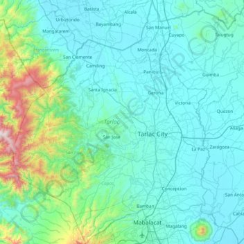
Name: Tarlac topographic map, elevation, terrain.
Location: Tarlac, Central Luzon, Philippines (15.16174 120.16247 15.87898 120.76478)
Average elevation: 217 m
Minimum elevation: 2 m
Maximum elevation: 1,937 m
Other topographic maps
Click on a map to view its topography, its elevation and its terrain.
Malolos
Malolos is relatively flat of about 0.81% to a gently sloping of 2.17%. The slope of the land descends towards west, southwest to southern direction. The highest land elevation is at about 6.0 meters above sea level while the lowest is only half a meter below sea level. A network of natural waterways and…
Average elevation: 6 m
Quezon City
Founded as a pueblo by Saint Pedro Bautista in 1590, San Francisco del Monte may be considered Quezon City's oldest district. The original land area of the old town of San Francisco del Monte was approximately2.5 square kilometres (1.0 sq mi) and covered parts of what is currently known as Project 7 and 8 and…
Average elevation: 57 m
Baguio
In 1903, Filipinos, Japanese and Chinese workers were hired to build Kennon Road, the first road directly connecting Baguio with the lowlands of La Union and Pangasinan. Before this, the only road to Benguet was Naguilian Road, and it was largely a horse trail at higher elevations. Camp John Hay was…
Average elevation: 881 m
Dasmariñas
Dasmariñas is partly lowland and partly hilly. The Poblacion itself is elevated. From an elevation of 80 meters (260 ft) at the Poblacion, the land rises to 250 meters (820 ft) towards Silang. Generally, land near rivers and creeks are rugged. Dasmariñas is outside the typhoon belt and has no fault line…
Average elevation: 97 m
Tuba
Tuba's topography is generally characterized by irregular rugged terrain and steep slopes with several mountain peaks rising from the table land itself. Mount Santo Tomas, the highest peak in the municipality soars to 2,252 metres (7,388 ft) above sea level.
Average elevation: 1,242 m
Sorsogon City
Sorsogon City covers a land area of 31,292 hectares (120.82 sq mi). It is at the southernmost tip of the Bicol Peninsula and of Luzon Island. The city is bounded by Castilla in the west, Manito in the northwest, Albay Gulf in the north, Prieto Diaz in the east, Gubat in the southeast, Casiguran in the…
Average elevation: 89 m
Montalban
Philippines > Rizal > Rodriguez
Rodriguez is generally very rough in topography, with 83% of its total land area composed of upland areas, hills and mountain ranges. The remaining 17% low-lying terrain and rolling lands are found at the south-western portion of the municipality, along with the northern portions of the Municipality of San…
Average elevation: 99 m
San Juan
"San Juan" is a contraction of the city's traditional name of "San Juan del Monte" (lit. 'Saint John of the Mountain'). As with numerous other places in the Philippines, the name combines a patron saint and a toponym; in this case Saint John the Baptist with the locale's hilly terrain and relatively higher…
Average elevation: 35 m
Calapan
Philippines > Oriental Mindoro
The overall land characteristic is a wide plain with rivers, interspersed with wetlands at the seacoast periphery. The highest elevation is 187 m (614 ft) above sea level at Bulusan Hill, a 6-kilometre (3.7 mi) long landform east of the city, which interrupts the mostly flat terrain north-east of the…
Average elevation: 40 m
Surigao City
Philippines > Surigao Del Norte
Surigao City is marked by rolling hills that gently buffers its eastern and western boundaries. To the south-west towers the Kabangkaan Ridge which divides the city from the municipality of San Francisco (formerly Anao-aon). Kinabutan River (otherwise known as Surigao River) meanders Surigao valley before it…
Average elevation: 40 m
Ilagan
Abuan River is the main river of the Northern Sierra Madre Natural Park. It has an average elevation of 82 meters above sea level, and feeds the Abuan watershed in the city. Tourists and visitors can explore the diverse animal and plant life in one of the country’s remaining lush virgin forests. On January…
Average elevation: 123 m
Tagum
One of the significant accomplishments of the officialdom of Tagum during the 1990s was its elevation from a second to the first-class municipality. This opened a gateway to increase its financial resources through the Internal Revenue Allocation (IRA) from the national government and local revenues. This was…
Average elevation: 103 m
Mandaluyong
Another claims that the Spaniards named the place based on the report of a navigator named Acapulco, who saw the rolling hills frequently being lashed at by daluyong (“big waves from the sea”). This seems to confirm traditional pre-Hispanic stories that giant waves from the sea would meet the adjoining…
Average elevation: 33 m
San Juan
"San Juan" is a contraction of the city's traditional name of "San Juan del Monte" (lit. 'Saint John of the Mountain'). As with numerous other places in the Philippines, the name combines a patron saint and a toponym; in this case Saint John the Baptist with the locale's hilly terrain and relatively higher…
Average elevation: 35 m
Valenzuela
The highest elevation point is 38 meters (125 ft) above sea level. Having a surface gradient of 0.55% and a gentle slope, hilly landscape is located in the industrial section of the city in Canumay. The average elevation point is 2 meters (6.6 ft) above sea level.
Average elevation: 24 m