
Make a donation
Romblon Island topographic map
Click on the map to display elevation.
Make a donation
About this map
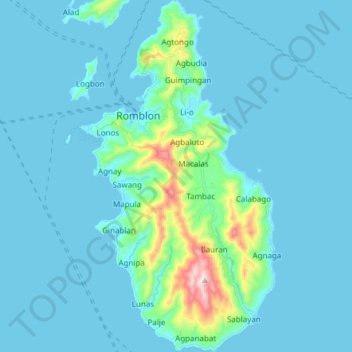
Name: Romblon Island topographic map, elevation, terrain.
Location: Romblon Island, Romblon, Mimaropa, Philippines (12.47796 122.24330 12.62590 122.32843)
Average elevation: 43 m
Minimum elevation: -1 m
Maximum elevation: 455 m
Make a donation
Other topographic maps
Click on a map to view its topography, its elevation and its terrain.
Looc
Looc is located along the shores of Looc Bay on the southern portion of Tablas Island. It is bordered to the north by the municipalities of Ferrol and Odiongan, to east by the municipality of Alcantara, to the south by the municipality of Santa Fe and to the west by Looc Bay and Tablas Strait. It has a total…
Average elevation: 51 m
Santa Fe
Santa Fe has a total land area of 63.52 km2. It lies on the southern tip of Tablas Island. The town is mountainous with so many beaches and islets. It has sandy loam type of soil rich with mineral resources such as granite and white clay. The tallest elevation in the town is Mount Calatong.
Average elevation: 7 m
Make a donation
Make a donation
Banton
The name "Banton" was derived from the Asi word batoon, meaning "rocky", referring to the mountainous and rocky topography of the island due to its volcanic origin. Another possible origin is the word bantoy, which is the Asi word for the venomous stonefish.
Average elevation: 3 m
Sibuyan Island
Sibuyan is a crescent-shaped island, the second largest in an archipelago comprising Romblon Province, Philippines. Located in the namesake Sibuyan Sea, it has an area of 445 square kilometres (172 sq mi) and has a total population of 62,815, as of the 2020 census. The island has two prominent peaks, the…
Average elevation: 182 m
Make a donation
Make a donation
Mount Guiting-Guiting
Philippines > Romblon > Cajidiocan
Mount Guiting-Guiting or G2 is the highest mountain in the province of Romblon, located in Sibuyan Island, in the Philippines, with an elevation of 6,752 ft (2,058 m) above sea level. Its steep slopes and jagged peak, have earned it the reputation, as one of the most difficult and technically most challenging…
Average elevation: 1,478 m
Make a donation
roadside view of Mt.Guiting-Guiting
Philippines > Romblon > Magdiwang > Sitio Agnonoc
Average elevation: 10 m
Make a donation
Make a donation
Make a donation
Make a donation
Banton
The name "Banton" was derived from the Asi word batoon, meaning "rocky", referring to the mountainous and rocky topography of the island due to its volcanic origin. Another possible origin is the word bantoy, which is the Asi word for the venomous stonefish.
Average elevation: 3 m
Make a donation
Sibuyan Island
Sibuyan is a crescent-shaped island, the second largest in an archipelago comprising Romblon Province, Philippines. Located in the namesake Sibuyan Sea, it has an area of 445 square kilometres (172 sq mi) and has a total population of 62,815 as of 2020 census. The island has two prominent peaks, the highest is…
Average elevation: 182 m
Make a donation
Make a donation
Make a donation