
Louisiana topographic map
Interactive map
Click on the map to display elevation.
About this map
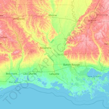
Name: Louisiana topographic map, elevation, terrain.
Location: Louisiana, United States (28.85429 -94.04319 33.01959 -88.75833)
Average elevation: 39 m
Minimum elevation: -4 m
Maximum elevation: 196 m
The higher and contiguous hill lands of the north and northwestern part of the state have an area of more than 25,000 square miles (65,000 km2). They consist of prairie and woodlands. The elevations above sea level range from 10 feet (3 m) at the coast and swamp lands to 50–60 feet (15–18 m) at the prairie and alluvial lands. In the uplands and hills, the elevations rise to Driskill Mountain, the highest point in the state only 535 feet (163 m) above sea level. From 1932 to 2010 the state lost 1,800 square miles due to rises in sea level and erosion. The Louisiana Coastal Protection and Restoration Authority (CPRA) spends around $1 billion per year to help shore up and protect Louisiana shoreline and land in both federal and state funding.
Other topographic maps
Click on a map to view its topography, its elevation and its terrain.
Simms Landing
United States > Maryland > Charles County
Simms Landing, Charles County, Maryland, 20677, United States
Average elevation: 26 m
Renovo
United States > Pennsylvania > Clinton County
Renovo, Clinton County, Pennsylvania, 17764, United States
Average elevation: 378 m
Spring Grove
United States > Illinois > McHenry County
Spring Grove, McHenry County, Illinois, 60081, United States
Average elevation: 253 m
Anaheim
United States > California > Orange County
Anaheim, Orange County, California, United States
Average elevation: 89 m
Suffolk County
Suffolk County, New York, United States
Average elevation: 34 m
Bradford County
Bradford County, Florida, United States
Average elevation: 45 m
Sandy
United States > Oregon > Clackamas County
Sandy, Clackamas County, Oregon, 97055, United States
Average elevation: 247 m
Briartown
United States > Kentucky > Washington County > Springfield
Briartown, Springfield, Washington County, Kentucky, 40069, United States
Average elevation: 233 m
Rosa
United States > Alabama > Blount County
Rosa, Blount County, Alabama, United States
Average elevation: 234 m
Falls Township
United States > Pennsylvania > Bucks County
Falls Township, Bucks County, Pennsylvania, United States
Average elevation: 15 m
Los Angeles
United States > California > Los Angeles County
Los Angeles, Los Angeles County, California, United States
Average elevation: 241 m
Sandy Springs
United States > Georgia > Fulton County
Sandy Springs, Fulton County, Georgia, United States
Average elevation: 301 m
Columbus
United States > Georgia > Muscogee County
Columbus, Muscogee County, Georgia, United States
Average elevation: 130 m
Houghton
United States > Michigan > Houghton County
Houghton, Houghton County, Michigan, 49931, United States
Average elevation: 269 m
Day
United States > Florida > Lafayette County
Day, Lafayette County, Florida, 32013, United States
Average elevation: 27 m
Galilee
United States > New Jersey > Monmouth County > Monmouth Beach
Galilee, Monmouth Beach, Monmouth County, New Jersey, 07750, United States
Average elevation: 1 m
New York County
United States > New York > New York
New York County, New York, United States
Average elevation: 16 m
Chicago River
United States > Illinois > Cook County > Chicago
Chicago River, Chicago, Cook County, Illinois, United States
Average elevation: 183 m
Hemet
United States > California > Riverside County
Hemet, Riverside County, California, United States
Average elevation: 535 m
Shannon County
Shannon County, Missouri, United States
Average elevation: 308 m
Blue Point
United States > New York > Suffolk County > Town of Brookhaven
Blue Point, Town of Brookhaven, Suffolk County, New York, 11715, United States
Average elevation: 7 m
Mathew Lake Dam
United States > Texas > Dallas County > Sunnyvale
Mathew Lake Dam, Sunnyvale, Dallas County, Texas, 75182, United States
Average elevation: 137 m
Sunset
United States > South Carolina > Pickens County
Sunset, Pickens County, South Carolina, 29685, United States
Average elevation: 382 m
Hot Springs
United States > Arkansas > Garland County
Hot Springs, Garland County, Arkansas, United States
Average elevation: 172 m
Morgan Hill
United States > California > Santa Clara County
Morgan Hill, Santa Clara County, California, 95038, United States
Average elevation: 153 m
Greenfield
United States > Massachusetts > Franklin County > Greenfield
Greenfield, Franklin County, Massachusetts, 01301, United States
Average elevation: 99 m
Sorenson
United States > California > Alameda County > Hayward
Sorenson, Hayward, Alameda County, California, 94544, United States
Average elevation: 55 m
Portland
United States > Oregon > Multnomah County
Portland, Multnomah County, Oregon, United States
Average elevation: 77 m
Horseshoe Bend
United States > Idaho > Boise County
Horseshoe Bend, Boise County, Idaho, United States
Average elevation: 867 m
Natividad
United States > California > Monterey County
Natividad, Monterey County, California, United States
Average elevation: 90 m
Pleasant Grove
United States > Utah > Utah County
Pleasant Grove, Utah County, Utah, 84062, United States
Average elevation: 1,609 m
Bonsall
United States > California > San Diego County
Bonsall, San Diego County, California, 92003, United States
Average elevation: 98 m
Oregon City
United States > Oregon > Clackamas County
Oregon City, Clackamas County, Oregon, 97045, United States
Average elevation: 99 m
Salt Lake City
United States > Utah > Salt Lake County
Salt Lake City, Salt Lake County, Utah, United States
Average elevation: 1,592 m
South Haven
United States > Michigan > Van Buren County
South Haven, Van Buren County, Michigan, United States
Average elevation: 187 m
Tulsa
United States > Oklahoma > Tulsa County
Tulsa, Tulsa County, Oklahoma, United States
Average elevation: 221 m
Tacoma
United States > Washington > Pierce County
Tacoma, Pierce County, Washington, United States
Average elevation: 67 m
Vail
United States > Colorado > Eagle County
Vail, Eagle County, Colorado, 81657, United States
Average elevation: 2,953 m
Akron
United States > Ohio > Summit County
Akron, Summit County, Ohio, United States
Average elevation: 315 m
Iowa City
United States > Iowa > Johnson County
Iowa City, Johnson County, Iowa, United States
Average elevation: 216 m
Sugar Hill
United States > Georgia > Gwinnett County
Sugar Hill, Gwinnett County, Georgia, United States
Average elevation: 332 m
Rancho Cordova
United States > California > Sacramento County
Rancho Cordova, Sacramento County, California, United States
Average elevation: 31 m
Santa Rosa
United States > California > Sonoma County
Santa Rosa, Sonoma County, California, United States
Average elevation: 136 m
Alta Vista
United States > Iowa > Chickasaw County
Alta Vista, Chickasaw County, Iowa, United States
Average elevation: 360 m
Hayward
United States > California > Alameda County
Hayward, Alameda County, California, United States
Average elevation: 77 m
Monta Vista
United States > California > Santa Clara County > Cupertino
Monta Vista, Cupertino, Santa Clara County, California, 95014, United States
Average elevation: 107 m