
General Nakar topographic map
Interactive map
Click on the map to display elevation.
About this map
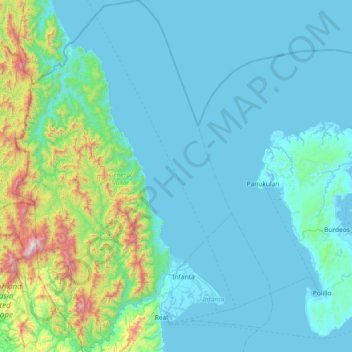
Name: General Nakar topographic map, elevation, terrain.
Location: General Nakar, Quezon, Calabarzon, 4338, Philippines (14.59527 121.29952 15.30202 121.73888)
Average elevation: 179 m
Minimum elevation: -1 m
Maximum elevation: 1,495 m
Other topographic maps
Click on a map to view its topography, its elevation and its terrain.
Mount Labo
Philippines > Quezon > Tagkawayan
Labo is a forested andesitic stratovolcano, surrounded by numerous andesitic to dacitic satellite lava domes. It has an elevation of 1,544 metres (5,066 ft) asl. Base diameter of this complex volcano is 35 kilometres (22 mi). Labo is thermally active with both warm and hot springs.
Average elevation: 1,052 m
Padre Burgos
On January 1, 1917, the village of Laguimanoc, which was formerly a barrio of Atimonan, became a municipality. On December 3, 1927, the town's name was changed to Padre Burgos by virtue of Act No. 3389, in honor of one of the country's martyrs, Fr. Jose Burgos. The streets were named after local leaders who…
Average elevation: 19 m
Pitogo
The fact that Pitogo is built on a promontory of rolling hills has a great rationale behind. Historical records show that this site was selected by the town's founders in 1766 because its lofty elevation provided them with good look out points for the marauding vintas of Muslim pirates who were then…
Average elevation: 9 m