
Make a donation
Pitogo topographic map
Click on the map to display elevation.
Make a donation
Pitogo
The fact that Pitogo is built on a promontory of rolling hills has a great rationale behind. Historical records show that this site was selected by the town's founders in 1766 because its lofty elevation provided them with good look out points for the marauding vintas of Muslim pirates who were then threatening the safety of the natives.
Make a donation
About this map
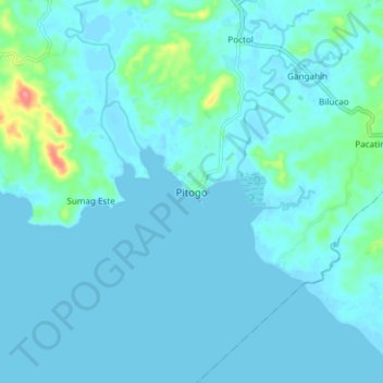
Name: Pitogo topographic map, elevation, terrain.
Location: Pitogo, Quezon, Calabarzon, 4308, Philippines (13.74324 122.04779 13.82324 122.12779)
Average elevation: 9 m
Minimum elevation: -4 m
Maximum elevation: 80 m
Make a donation
Other topographic maps
Click on a map to view its topography, its elevation and its terrain.
Sariaya
Sariaya is situated on a flat land except for a portion on the north occupying a part of the foot of Mount Banahaw. The municipality has the highest point of elevation on 3,800 feet above sea level at Barangays Concepcion Banahaw and Sampaloc Bogon.
Average elevation: 117 m
Make a donation
Make a donation
Make a donation
Make a donation
Make a donation
Make a donation
Make a donation
Make a donation
Make a donation
Make a donation
Make a donation
Laguna-Quezon Land Grant Lagoon
Philippines > Quezon > Real > Magsaysay > Maunlad
Average elevation: 389 m
Make a donation
Make a donation
Make a donation
Make a donation
Sariaya
Sariaya is situated on a flat land except for a portion on the north occupying a part of the foot of Mount Banahaw. The municipality has the highest point of elevation on 3,800 feet (1,200 m) above sea level at Barangays Concepcion Banahaw and Sampaloc Bogon.
Average elevation: 117 m
Make a donation
Make a donation
Make a donation
Make a donation
Make a donation