
Thank you for supporting this site ❤️
Make a donation
Make a donation
Tignoan topographic map
Click on the map to display elevation.
Thank you for supporting this site ❤️
Make a donation
Make a donation
About this map
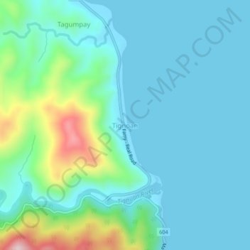
Name: Tignoan topographic map, elevation, terrain.
Location: Tignoan, Real, Quezon, Calabarzon, 4335, Philippines (14.55647 121.59838 14.59647 121.63838)
Average elevation: 66 m
Minimum elevation: -1 m
Maximum elevation: 355 m
Thank you for supporting this site ❤️
Make a donation
Make a donation
Other topographic maps
Click on a map to view its topography, its elevation and its terrain.
Laguna-Quezon Land Grant Lagoon
Philippines > Quezon > Real > Magsaysay > Maunlad
Average elevation: 389 m