
Menoua topographic map
Interactive map
Click on the map to display elevation.
About this map
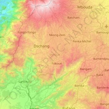
Name: Menoua topographic map, elevation, terrain.
Location: Menoua, Région de l'Ouest, Cameroun (5.17470 9.83153 5.63880 10.33808)
Average elevation: 1,306 m
Minimum elevation: 194 m
Maximum elevation: 2,738 m
Other topographic maps
Click on a map to view its topography, its elevation and its terrain.
Tchang I
Cameroun > Région de l'Ouest > Menoua > Penka-Michel > Bamendou II
Average elevation: 1,526 m