
Megom topographic map
Interactive map
Click on the map to display elevation.
About this map
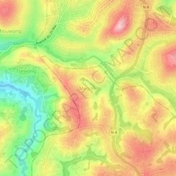
Name: Megom topographic map, elevation, terrain.
Location: Megom, Pete-Bandjoun, Nkoung-Khi, Région de l'Ouest, Cameroun (5.42282 10.39436 5.46282 10.43436)
Average elevation: 1,449 m
Minimum elevation: 1,338 m
Maximum elevation: 1,543 m
Other topographic maps
Click on a map to view its topography, its elevation and its terrain.
Bandjoun
Cameroun > Région de l'Ouest > Nkoung-Khi > Pete-Bandjoun
Bandjoun, Pete-Bandjoun, Nkoung-Khi, Région de l'Ouest, Cameroun
Average elevation: 1,538 m