
Bandjoun topographic map
Interactive map
Click on the map to display elevation.
About this map
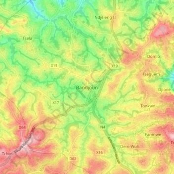
Name: Bandjoun topographic map, elevation, terrain.
Location: Bandjoun, Pete-Bandjoun, Nkoung-Khi, Région de l'Ouest, Cameroun (5.33486 10.37216 5.41486 10.45216)
Average elevation: 1,538 m
Minimum elevation: 1,406 m
Maximum elevation: 1,675 m
Other topographic maps
Click on a map to view its topography, its elevation and its terrain.
Megom
Cameroun > Région de l'Ouest > Nkoung-Khi > Pete-Bandjoun
Megom, Pete-Bandjoun, Nkoung-Khi, Région de l'Ouest, Cameroun
Average elevation: 1,449 m