
Make a donation
Wales topographic map
Click on the map to display elevation.
Make a donation
Wales
Wales is predominantly mountainous, with its terrain shaped by ancient geological processes and glaciation. In the north, Snowdonia (Eryri) boasts the country's highest peaks, including Snowdon (Yr Wyddfa) at 1,085 meters (3,560 feet). Central Wales is characterized by the Cambrian Mountains, featuring rounded, undulating landscapes covered in moorland and rough grassland. The southern region is home to the Brecon Beacons (Bannau Brycheiniog), with notable summits like Pen y Fan at 886 meters (2,907 feet). Beyond its uplands, Wales offers diverse lowland areas, including the north coastal plain, the island of Anglesey, parts of the Llŷn Peninsula, narrow coastal strips along Cardigan Bay, much of Pembrokeshire and southern Carmarthenshire, the Gower Peninsula, and the Vale of Glamorgan. The country's extensive coastline, stretching approximately 1,370 miles (2,200 kilometers), features a mix of rugged cliffs and sandy beaches, further enriching its varied topography.
Make a donation
About this map
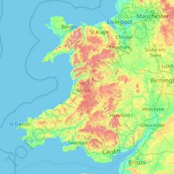
Name: Wales topographic map, elevation, terrain.
Location: Wales, United Kingdom (51.22903 -5.80773 53.63500 -2.64986)
Average elevation: 99 m
Minimum elevation: 0 m
Maximum elevation: 1,000 m
Make a donation
Other topographic maps
Click on a map to view its topography, its elevation and its terrain.
Eastnor Castle
United Kingdom > England > Herefordshire > Eastnor > Wayend Street
Average elevation: 125 m
Make a donation
Windsor Castle
United Kingdom > England > Royal Borough of Windsor and Maidenhead > Windsor > Clewer Village
Average elevation: 23 m
Make a donation
Whitwood Wharf
United Kingdom > England > Wakefield > Normanton and Altofts > Whitwood
Average elevation: 19 m
Make a donation
Kinlochleven
United Kingdom > Scotland > Highland
Work on the dam and water supply system began in 1905 and was completed in 1907. The hydro-electric scheme was constructed for the British Aluminium Company and was designed by engineer brothers Patrick and Charles Meik. The chief assistant resident engineer on the project was a young William Halcrow. The…
Average elevation: 306 m
Make a donation
Make a donation
Upper Mill Pond
United Kingdom > England > South Gloucestershire > Oldland Common
Average elevation: 42 m
Make a donation
Make a donation
Littlestone on Sea
United Kingdom > England > Kent > Folkestone and Hythe District > New Romney
Average elevation: 1 m
Make a donation
Make a donation
Make a donation
Scottish Highlands
United Kingdom > Scotland > Highland
The entire region was covered by ice sheets during the Pleistocene ice ages, save perhaps for a few nunataks. The complex geomorphology includes incised valleys and lochs carved by the action of mountain streams and ice, and a topography of irregularly distributed mountains whose summits have similar heights…
Average elevation: 907 m
Make a donation
Ashurst Bridge
United Kingdom > England > Hampshire > New Forest > West Totton
Average elevation: 17 m
Shropshire Union Canal Newport Branch
United Kingdom > England > Telford and Wrekin > Newport
Average elevation: 77 m
Make a donation
Harrogate
United Kingdom > England > North Yorkshire
Harrogate is situated on the edge of the Yorkshire Dales, with the Vale of York to the east and the upland Yorkshire Dales to the west and north-west. It has a dry and mild climate, typical of places in the rain shadow of the Pennines. It is on the A59 from Skipton to York. At an altitude of between 100 and…
Average elevation: 106 m
Clapham
In 1848, Clapham was described in the Topographical Dictionary of England as a village which "has for many years, been one of the most respectable in the environs of the metropolis". At this time, the patronage of Holy Trinity church belonged to the Atkins family.
Average elevation: 22 m
Make a donation
Make a donation
Glasgow
United Kingdom > Scotland > Glasgow City
Glasgow itself was reputed to have been founded by the Christian missionary Saint Mungo in the 6th century. He established a church on the Molendinar Burn, where the present Glasgow Cathedral stands, and in the following years Glasgow became a religious centre. Glasgow grew over the following centuries. The…
Average elevation: 128 m
Make a donation
Gwyrch Castle Northern Towers
United Kingdom > Wales > Conwy > Llanddulas > Terfyn
Average elevation: 54 m
Make a donation
Sawmills
United Kingdom > England > Derbyshire > Amber Valley > Ripley > Fritchley
Average elevation: 119 m
Make a donation
Make a donation
Chard
United Kingdom > England > Somerset
Chard is a town and a civil parish in the English county of Somerset. It lies on the A30 road near the Devon and Dorset borders, 15 miles (24 km) south west of Yeovil. The parish has a population of approximately 14,000 and, at an elevation of 121 metres (397 ft), Chard is the southernmost and one of the…
Average elevation: 135 m
Temple Guiting
United Kingdom > England > Gloucestershire > Cotswold District
Average elevation: 241 m
Make a donation
Thames Head
United Kingdom > England > Gloucestershire > Cotswold District > Kemble
Average elevation: 117 m
Scarborough
United Kingdom > England > North Yorkshire
The climate is temperate with mild summers and cool, windy, winters. The hottest months of the year are July and August, with temperatures reaching an average high of 17 °C and falling to 11 °C at night. The average daytime temperatures in January are 4 °C, falling to 1 °C at night. The station's elevation…
Average elevation: 39 m
Hull
United Kingdom > England > Kingston upon Hull
Kingston upon Hull is on the northern bank of the Humber Estuary. The city centre is west of the River Hull and close to the Humber. The city is built upon alluvial and glacial deposits which overlie chalk rocks but the underlying chalk has no influence on the topography. The land within the city is generally…
Average elevation: 21 m
Make a donation
Make a donation
Make a donation
Holme-on-Spalding-Moor
United Kingdom > England > East Riding of Yorkshire > Holme-on-Spalding-Moor
Average elevation: 8 m
Make a donation
Clewer Village
United Kingdom > England > Royal Borough of Windsor and Maidenhead
Average elevation: 26 m
Upper Rissington
United Kingdom > England > Gloucestershire > Cotswold District
Average elevation: 184 m
Make a donation