Geolocate

Canberra topographic map

Click on the map to display elevation.

Canberra

The area chosen for the capital had been inhabited by Aboriginal Australians for up to 21,000 years, by groups including the Ngunnawal and Ngambri. European settlement commenced in the first half of the 19th century, as evidenced by surviving landmarks such as St John's Anglican Church and Blundells Cottage. On 1 January 1901, federation of the colonies of Australia was achieved. Following a long dispute over whether Sydney or Melbourne should be the national capital, a compromise was reached: the new capital would be built in New South Wales, so long as it was at least 100 mi (160 km) from Sydney. The capital city was founded and formally named as Canberra in 1913. A plan by the American architects Walter Burley Griffin and Marion Mahony Griffin was selected after an international design contest, and construction commenced in 1913. Unusual among Australian cities, it is an entirely planned city. The Griffins' plan featured geometric motifs and was centred on axes aligned with significant topographical landmarks such as Black Mountain, Mount Ainslie, Capital Hill and City Hill. Canberra's mountainous location makes it the only mainland Australian city where snow-capped mountains can be seen in winter, although snow in the city itself is uncommon.

Wikipedia (CC-BY-SA 3.0)

About this map

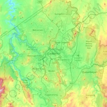
Name: Canberra topographic map, elevation, terrain.

Location: Canberra, District of Canberra Central, Australian Capital Territory, 2600, Australia (-35.45759 148.94127 -35.13759 149.26127)

Average elevation: 638 m

Minimum elevation: 395 m

Maximum elevation: 1,238 m

Other topographic maps

Click on a map to view its topography, its elevation and its terrain.

Mount George

Australia > New South Wales

Average elevation: 180 m

The Gurdies

Australia > Victoria

Average elevation: 58 m

Thumb Creek

Australia > New South Wales

Average elevation: 344 m

Newnes Plateau

Australia > New South Wales

Average elevation: 889 m

Highton

Australia > Victoria > Geelong

Average elevation: 52 m

Southport

Australia > Litchfield Municipality

Average elevation: 12 m

Shire of Wellington

Australia > Victoria

Average elevation: 331 m

Mahomets Flats

Australia > Western Australia

Average elevation: 16 m

South Yarra

Australia > Victoria > Melbourne

Average elevation: 19 m

Dysart

Australia > Queensland

Average elevation: 253 m

Leura

Australia > New South Wales > Sydney

Leura's elevation of 985 metres (3,232 ft) AHD leads to occasional snowfall in winter and a climate that reflects all four seasons distinctly.

Average elevation: 878 m

Northern Beaches

Australia > New South Wales > Sydney

Average elevation: 67 m

Wooli

Australia > New South Wales

Average elevation: 9 m

Crystal Creek

Australia > New South Wales

Average elevation: 60 m

Slade Point

Australia > Queensland > Mackay

Average elevation: 5 m

Bellerive

Australia > Tasmania > Hobart

Average elevation: 25 m

City of Swan

Australia > Western Australia

Average elevation: 156 m

Kellyville

Australia > New South Wales > Sydney

Average elevation: 70 m

Rixs Creek

Australia > New South Wales

Average elevation: 104 m

The Gap

Australia > Queensland > Brisbane City

Average elevation: 107 m

Brighton

Australia > Victoria > Melbourne

Average elevation: 13 m

Valla

Australia > New South Wales

Average elevation: 45 m

Gosford

Australia > New South Wales

Average elevation: 25 m

Cooyal

Australia > New South Wales

Average elevation: 596 m

Glen Huon

Australia > Tasmania

Average elevation: 247 m

Huonville

Australia > Tasmania

Average elevation: 161 m

Glen Innes

Australia > New South Wales

Average elevation: 1,083 m

Kingsgate

Australia > New South Wales

Average elevation: 883 m

Hargraves

Australia > New South Wales

Average elevation: 685 m

Adelaide

Australia > South Australia > Adelaide City Council

Based on the ideas of Edward Gibbon Wakefield about colonial reform, Robert Gouger petitioned the British government to create a new colony in Australia, resulting in the passage of the South Australia Act 1834. Physical establishment of the colony began with the arrival of the first British colonisers in…

Average elevation: 146 m

Parliament Gardens

Australia > Victoria > Melbourne

Average elevation: 32 m

Bankstown

Australia > New South Wales > Sydney

Average elevation: 34 m

Cape Gloucester

Australia > Queensland

Average elevation: 56 m

Kiamba

Australia > Queensland > Sunshine Coast Regional

Average elevation: 148 m

Mer Island

Australia > Queensland

Average elevation: 30 m

Dharruk

Australia > New South Wales > Sydney

Average elevation: 51 m

Murray River

Australia

Average elevation: 158 m

Glenbrook

Australia > New South Wales > Sydney

Average elevation: 168 m

Gladstone Regional

Australia > Queensland

Average elevation: 116 m

Maroubra

Australia > New South Wales > Sydney

Average elevation: 27 m

Torrens

Australia > District of Woden Valley

Average elevation: 661 m

Mackay Regional

Australia > Queensland

Average elevation: 99 m

Kingston

Australia > Tasmania > Hobart

Average elevation: 127 m

Rose Bay

Australia > New South Wales

Average elevation: 31 m

Heard Island and McDonald Islands

Australia

Heard Island, by far the largest of the group, is a 368-square-kilometre (142 sq mi) mountainous island covered by 41 glaciers (the island is 80% covered with ice) and dominated by the Big Ben massif. It has a maximum elevation of 2,745 metres (9,006 ft) at Mawson Peak, the historically active volcanic summit…

Average elevation: 12 m

Watsonia

Australia > Victoria > Melbourne

Average elevation: 85 m

Arakoon

Australia > New South Wales

Average elevation: 11 m

Kew

Australia > New South Wales

Average elevation: 65 m

South Australia

Australia

Average elevation: 110 m

New South Wales

Australia

New South Wales (NSW), located on Australia's eastern seaboard, boasts a diverse topography that significantly influences its landscapes and ecosystems. The state's eastern edge is dominated by a narrow coastal plain, featuring regions such as the Illawarra and Shoalhaven near Nowra, characterized by rolling…

Average elevation: 154 m

Queenstown

Australia > Tasmania

Average elevation: 330 m

Katherine

Australia > Town of Katherine

Average elevation: 106 m

Launceston

Australia > Tasmania

Launceston is at 41°26′31″S 147°8′42″E / 41.44194°S 147.14500°E / -41.44194; 147.14500 in the Tamar Valley, Northern Tasmania. The valley was formed by volcanic and glacial forces over 10 million years ago. The city is about 45 kilometres (28 mi) south of the Bass Strait, with its closest…

Average elevation: 194 m

Stanmore

Australia > New South Wales > Sydney

Average elevation: 27 m

Macksville

Australia > New South Wales

Average elevation: 10 m

Soldiers Hill

Australia > Queensland

Average elevation: 352 m

Huntingwood

Australia > New South Wales > Sydney

Average elevation: 63 m

Hobart

Australia > Tasmania

Although Hobart itself rarely receives snow during the winter due to the foehn effect created by the Central Highlands (the city's geographic position causes a rain shadow), the adjacent Kunanyi/Mount Wellington is frequently seen with a snowcap throughout the year including in summer. During the 20th century,…

Average elevation: 179 m

Hyams Beach

Australia > New South Wales

Average elevation: 34 m

Sunny Corner

Australia > New South Wales

Average elevation: 1,119 m

Bellbowrie

Australia > Queensland > Brisbane City

Average elevation: 31 m

Cocos (Keeling) Islands

Australia

The Cocos (Keeling) Islands consist of two flat, low-lying coral atolls with an area of 14.2 square kilometres (5.5 sq mi), 26 kilometres (16 mi) of coastline, a highest elevation of 5 metres (16 ft) and thickly covered with coconut palms and other vegetation. The climate is pleasant, moderated by the…

Average elevation: 0 m

Bega River

Australia > New South Wales > Tathra > Chinnock

Average elevation: 46 m

Retro

Australia > Queensland

Average elevation: 302 m

Orbost

Australia > Victoria

Average elevation: 114 m

Westgrove

Australia > Queensland

Average elevation: 540 m

Chute

Australia > Victoria

Average elevation: 429 m

Tablelands Regional

Australia > Queensland

Average elevation: 567 m

Campbell Town

Australia > Tasmania > Campbell Town

Average elevation: 345 m

Science Garden

Australia > Victoria > Melbourne

Average elevation: 174 m

Moreton Bay Regional

Australia > Queensland

Average elevation: 110 m

Truganina

Australia > Victoria > Melbourne > Truganina

Average elevation: 57 m

Colac

Australia > Victoria > Colac

Average elevation: 127 m

Warrnambool

Australia > Victoria > Warrnambool

Average elevation: 19 m

City of Greater Geelong

Australia > Victoria

Average elevation: 77 m

Legana

Australia > Tasmania > Launceston > Legana

Average elevation: 82 m

Clarence Point

Australia > Tasmania > Clarence Point

Average elevation: 13 m

Exeter

Australia > Tasmania > Exeter

Average elevation: 70 m

Fern Tree

Australia > Tasmania > Hobart

Average elevation: 404 m

Deloraine

Australia > Tasmania > Deloraine

Average elevation: 274 m

Katanning

Australia > Western Australia > Katanning

Katanning railway station has an elevation of 1,024 feet (312 m) above sea level and a rail distance of 225 miles (362 km) from Perth.

Average elevation: 323 m

Moama

Australia > New South Wales

Average elevation: 96 m

North Burnett Regional

Australia > Queensland

Average elevation: 277 m